ÇATALHÖYÜK 1998 ARCHIVE REPORT
    |
Archive Report for the Mellaart Area 1998
Shahina Farid
Introduction
Excavation continued from last season in structures on the northern side of the 20 x 20 m area targeted for deep excavation for the investigation of the early activity on the east mound.
The structures under discussion in this report are Buildings 2 and 4, Spaces 112, 115, 159 and 160. Building 4, is located towards the north-east of the excavation area, consisting of a small room in the south-east corner, Space 150, accessed from the west from the larger room, Space 151. Space 112 is located to the west of Building 4, and to the south is the 'external' area known as Space 115. To the east of that lies Building 2, consisting of a large rectangular room, Space 117 and a small room connected by a crawl hole, to the east, Space 116. Additionally two new structures were excavated which are located to the south of Building 2. These were Space 159, the ante-chamber to Shrine 10, Level VII in Mellaart's phasing, and to the immediate south of that a small structure, Space 160, which was marked as House 11 on published plans.
Long overdue time was also spent unravelling the sequence of walls at the junction of Spaces 114 and 115, and Buildings 2 and 4.
Building 4
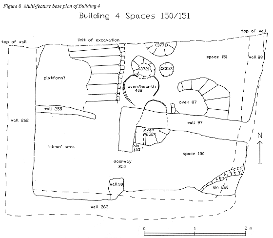
Most of this season was spent excavating the fine and complex stratigraphy of the ovens and the surrounding floor deposits of occupation debris and the features and floors in the inner room. The western half of the building, the 'clean' area, was not investigated. Three phases of oven activity were excavated in Space 151 and two phases of activity identified in Space 150.
The earliest deposit, [3787/3782], was present in both spaces and represented a pre-occupation deposit, possibly the infilling of an earlier phase. A primary oven/hearth (not fully excavated), cut through this deposit to the east of the plaster ridge. It had a lining discoloured through in situ heat penetration represented by [3778] and [3977/3780] and the associated floors were represented by [3971], [3962], [3961], [3959], [3956], [3955] and [3954]. Floors associated with 'dirty' areas were characterised as compacted occupation debris probably originating from activities taking place in the vicinity, which in this context was the use of ovens. At any one given time each deposit will therefore have formed part of a floor. The floors are consequently not continuous or uniform in composition or appearance. There was no evidence of a uniform primary floor unless [3787/3782] interpreted as the pre-occupation infilling, represents such an event. The oven/hearth was sealed over by floor [3968] at the end of its use.
A more substantial floor ([3976/3794/3766]) of compacted occupation debris sealed another hearth-like feature ([3771], 3770] and [3769]) located against the north section, and to the north of that further patches of floor ([3729], [3793] and [3726]) were traced. Through this horizon were cut posthole-type features, cut [3723], a 0.45m diameter x 0.12 deep filled by [3721], a sterile homogenous clayey silt, and cut [3741] which was 0.26m diameter x 0.13 deep filled by [3739], a plastery fill. A similar feature ([2357], [2356]) was excavated last year. Their contemporaneity is unclear as they appear at the latest floor horizon and as such are unclear in function.
Overlying the primary oven/hearth were truncated deposits representing the construction of succeeding oven 252. As these deposits were found to be interdigitated with the floor deposits to the north they probably represented successive plaster renderings to the oven superstructure thorough its life-use. Oven 252 was constructed in a semi-circular hole cut through wall 97, the east-west aligned party wall between Spaces 150 and 151. In Space 150 the oven cavity was located in the extreme north west corner where the dome of the oven was constructed. The oven was therefore accessed from Space 151. At the end of its use it had been truncated to floor level and so it is not clear whether this side also had a domed superstructure or some form of rim construction, as only the oven floor and surrounding imprint survived. Unit [3755] represented a small fragment of the rim in Space 151, which presumably stood proud as part of the oven wall, up to which floors [3772/3751/ 3763/3764] lipped. A subsequent rim foundation [3396] was overlain by oven construction make-up [3363], pale grey brown silt traced through the wall cavity into Space 150, in turn overlain by the smooth fire baked oven floor [3351]. In Space 150 foundation layer [3363] also sealed a series of oven construction deposits. Units [3372] and [3381] represented fragments of the superstructure, unit [3384] the domed superstructure which formed the back of the oven while [3622] and [3627] were inner linings of the oven cavity. The equivalent deposits of lining in the wall cavity were [3356], [3320] and [3334]. When redundant the oven was cut back to the wall face and the hole in the wall backfilled ([3336]) from Space 151.
Two broad phases of floor were associated with the use of 252, [3772/3751/3763/3764] overlain by floors [3148/3149/3155/3156] and [3133], [3182] [3183]. The latter floors were cut through as part of the construction of the latest oven 87 in Space 151. It was a domed mud plaster structure constructed in cut [3138], which also partially cut into the north face of wall 97. Its construction was represented by plaster fragments [3750] and foundation or primary oven floor [3139] overlain by make-up deposit [3130], over which [3123] and [3122], [3116] were basal renderings of the superstructure walls. Units [2870], [3127] and [2843] represented the main construction of the oven superstructure, forming a dome constructed against wall 97, measuring 1.2m x 0.8m x up to 0.23m high with an entrance to the west. An internal lining [2860] was reddened through heat penetration and the lining consisted of a fibrous rich silty clay matrix applied in visible layers.
An ashy deposit [2891] wedged in the corner of the oven wall and basal make-up represented a use of the oven but as this pre-dated the main oven floor it can be interpreted as either a primary use, or, re-deposited material from one of the earlier ovens. The primary oven floor [2865] was smooth surfaced and fire baked. This was clean apart from one patch of ash [2859] and two stones. A further deposit [2864] was a fragment of lining collapse. The oven was clearly deliberately cleaned prior to a careful infilling exercise represented by [2852/2005]. The infill was a sterile clayey silt, infilling the oven up to the roof via the entrance to the west. Units [2851/2004] and [2848/2003] represent collapsed lining and roof structure but clearly post infill.
In the north east corner were a series of discontinuous occupation/floor deposits. These were represented by [3744] in the extreme north east corner and [3745], a basal make-up type deposit in the south east corner, overlain by occupation deposit [3184]. A subsequent layer of relatively clean brown silt [3165/3174/3178] may represent floors or the base of a platform. Distinctions between deposits in this corner have always been visible but they have been too heavily truncated to interpret. The archaeological sequence in this north section is also at complete odds to the area under excavation. Clearly the edge of excavation has clipped a major change in activity areas.
In Space 151 oven 252 was constructed over an earlier feature 407, interpreted as a sunken plaster lined basin-type feature. This was a cut [3700] measuring the length of the wall to the west x 0.31m x up to 0.15m deep, which cut through make-up layer [3708]. Units [3638] and [3637] represented its plaster lining, slivers of deposits surviving on the southern edge only. The cut was backfilled at the time of the oven construction by [3631], which was also part of the oven superstructure.
Unit [3395] represented a sliver of possible floor around the edge of 'basin' 407 overlain by a similar deposit [3390]. These deposits were sealed by the construction of oven 252. One interpretation is that after the construction of the 'oven', Space 150 was closed off and even possibly backfilled; to support this was the absence of contemporary floors. However the evidence to verify or contradict this theory was lacking due to the post-use floor scouring and later activities
'Bin' 280 occupied the south-east corner constructed of a thin mud plaster wall with multiple plaster applications [3704], [3391], [3385] and [3371]. Subsequent floor and make-up deposits were traced around the feature lipping up to and along its wall face and across the floor to the south, discontinuous through truncation by later activities. These floors were represented as [3321/3322/3323/3324] and overlain by [3169/3168/3166/3167/3711]. Wall 99 was then constructed abutting the south wall in the doorway between Spaces 150 and 151. This reduced doorway 250 from a width of 1.0m to 0.64m. Wall 99 was constructed over the latest floor [3188]. Initially it appeared to have been constructed into a cut in the southern wall 263, but upon excavation it was found to fill an overhang in the wall. This overhang stretched along the length of the south wall in Space 151 but not in Space 150 despite being the same wall. Wall 99 may have been constructed to function as a support buttress at the junction of the overhang. Post-wall 99 floors [3164/3152/3135/3151] once again only survived along the southern edge of the room.
Because of the floor-scouring event at the end of the life span of the building no one area of the building can be easily traced and linked to another. This and the retrieval of the posts were the last events to take place before the building was backfilled and the succeeding building, Space 113 established.
Space 112
Space 112 was successfully completed this year. A further two burials were excavated, located in the north east corner. The earliest of these two burials was 274, a flexed infant burial [2842], with a small stone bowl located by its head in the 'V' of the torso and drawn up flexed legs. Its lower torso was disturbed by the later burial 277, a beautifully preserved, tightly flexed adult burial [2886].
These two burials bring the total inhumations excavated in Space 112 to ten in an area measuring just 2.4 x 3.6 m. The total number of burials in this building cannot however be estimated as Mellaart excavated an unknown number, and burials continue beyond the area under excavation to the north. Of the burials excavated only two were attributed to platform 86, located in the south west corner. The survival of this platform was due only to the fact that the southern wall 85 was a later construction over the platform and it therefore survived excavation by the previous expedition. It is probable however that most of the burials were associated with platforms shown on Mellaart's plans.
Two pit cuts [2360] and [2738] were excavated last season but were found to have been under-dug. Further excavation revealed lower infill deposits in both cases thereby creating deeper cuts. Cut [2360] located against the west wall, was filled by [2359] and [2358] and included a further fill [2047/3190] of mixed fragments of brick and plaster. The cut was renumbered as [2875/3199], and the whole sequence brought together under feature number 275. Cut [2738] located against the east wall was found to contain a lower fill [2853], a similar fill of mixed debris containing fragments of brick and plaster within cut [2855], and this whole sequence was brought together under feature number 276. The lower fills were clearly dissimilar to the upper fills, which were predominantly of plaster fragments and interpreted as the ritual burial of dismantled wall mouldings. However the location of these features also suggests they represent post retrieval pits on the basis of their location when compared to Mellaart's report plans. If this interpretation is correct these cuts would represent one of the latest events to have taken place in Space 112.
Infilling
The basic composition of these deposits was the same, differentiated by slight variations in colour, size and abundance of inclusions, with some layers containing more 'midden' elements as inclusions. These deposits were the discussion of some priority tours this season and the variations in these deposits were interpreted as material originating from different but similar sources. The surface horizons of these deposits were also under discussion as they were unusually evenly distributed with no clear tip lines indicating the direction of infilling. Except for the basal fill [3380/3129/3107], which was mounded in the centre, falling at a steep slope-off towards the sides the surfaces were generally flat with a shallow slope-off around the edges. The ensuing picture is that more than one individual was involved in the infilling process, importing material from different sources, which was roughly levelled off in situ.
The basal unexcavated layer [3163] covered the occupation activity and floors of Space 162 but represents the same deposit excavated as [3380/3129/3107]. The following deposits were excavated from bottom up, [2897/3733], [2890/3361], [2876/3310] and [3749/2844/3195/3114] the latest of which would have been the foundation deposit for the floors of Space 112. Included in this sequence are also the layers excavated last season as [2776], [2305], [2375].
These deposits appear to be imported material, as they do not seem to derive from material originating from a known source under excavation. They also appear to have been reworked with characteristics of some form of screening. The composition was of comparatively small particles with a notable absence of large material assemblage associated with 'ash midden' or refuse deposits found in the 'external' area Space 115, nor the more dump-like waste deposits excavated in Space 117. These deposits were not however, dissimilar to those excavated in pre-Space 109 and pre- Space 113 which also appeared to have been imported and screened, although there was no trace of internal bedding as there was below 112. All displayed characteristics of rapid deposition with little or no time lapse during the process.
Construction of Space 112 Walls
The aim of levelling earlier walls would have been to provide a firm and stable construction horizon for new walls and also necessary after the dismantling of the roof. A characteristic peculiarity of this phase of events is that there was no evidence of roof removal or wall levelling, all signs of debris from this exercise appearing to have been cleared away prior to the infilling process. Is it possible that it is this material which was screened and used as infilling? In relation to Spaces 112 and 162 the only indication of this may be seen in the presence of grey brick fragments contained throughout the infill deposits matching the brick colour of the walls of Space 162.
The sequence of wall construction and infilling is not always apparent in the archaeological record, but in this case it would appear that the walls to Space 112 were constructed prior to the infilling event. This is because the depth of the infill exceeded the depth of the base of the later walls. This sequence is also suggested because of the absence of a compact 'worn' horizon that would indicate an activity horizon from where the walls may have been constructed, a possible scenario in Space 113.
The walls of Space 112 were completely excavated this season highlighting a mistake in the wall sequence recorded in last seasons archive report. There are still inconsistencies within some of these wall relationships, which need more deliberation.
The west wall 267 was recorded as one of the earliest walls in this location because of a plaster rendering on both its faces and the fact that it was abutted by wall 286 in the south west corner. Upon excavation it was found that the upper 2/3 courses of wall 267 were of a different construction, composed of a slightly paler shade of brick and mortar and was very slightly narrower in width. These upper courses only were abutted by the south wall 286. This still poses a stratigraphic problem as the lower courses of wall 267 and 286 were bonded.
The south wall 286 was then bonded to the lower courses of wall 267 to the west. To the east wall 286 appears to continue eastwards beyond the boundaries of Space 112 and at the current stage of excavation appears to be the same wall as 282 (north east section of wall to Space 115).
The eastern wall 259 abutted the south wall 286. This wall had a severe slump/overhang/lean towards the west, which was also reflected in wall 90 (west wall of Space 113 excavated last season). A westward slump to differing degrees appeared to be a characteristic of most north-south aligned walls, which may have been due to the east-west terracing of the site. The slump in Space 112 was addressed at some stage of the building's lifetime by the construction of support wall 253. This was initially recorded as a continuous north-south wall built against wall 259, however it only stretched half the length of the east wall and was cut into wall 286 in the south east corner wall. It also appeared to have been built over the lower courses of 259, but there was no sign of a construction cut for the later wall. Also exposed behind it was what appeared to be yet another wall between Space 112 and Building 4, with fragments of wall plaster adhering to its west face. At this stage this information is indicative of a lost phase of activity. Furthermore complications exist with late support wall 85, which was interpreted as the same phase as wall 253 due to its bonded relationship in the south-east corner, but on the basis of their differing depths would now appear different.
Phase-wise, although Spaces 112, 107 and 108 are attributable to Mellaart's level VII, the construction of Space 112 may have pre-dated that of wall 52, the north wall of Spaces 107 and 108. This is based upon a slight southward lean in wall 286, which may not have occurred had wall 52 been extant and acted as a support.
The bricks and mortar used to construct the Space 112 walls were of the same composition and despite the clarity of mortar and brick courses in elevation they were very difficult to define in excavation, being fused, and irregular at the basal boundaries. This suggests construction took place when the building material was still malleable and therefore settled after construction. The interface of Space 112 walls and Space 162 walls was also not the usual evenly levelled horizon but irregular and convex, possibly intended as a keying device. A further feature was a shallow westward stepping in the southern wall, again reflecting the terrace of the site and also a feature of the south wall to Building 4 and the south wall to Spaces 107 and 108.
Space 162
Space 115
The method adopted for the excavation of these deposits was not by the conventional method of isolating discreet deposits as this was found to be slow and difficult because of their very fine lenses, the interdigitated nature and close similarities in composition. It was found to be more effective to excavate activity horizons, although similar to the floor deposits in 'dirty' areas of houses, as at any given moment each 'midden' deposit would have formed part of a surface. Although not a satisfactory method of excavation it was effective without undue information loss.
These deposits are characterised as fine interdigitated lenses of ash and charcoal debris with lenses and particles of clay, plaster and organic components of either food or coprolite. They are also rich in waste debris of bone, obsidian, clay balls, figurine fragments etc., and were interpreted as primary deposition of domestic waste accumulated over time and in rapid succession, based on the infrequency of wear and/or weathering indications. The deposits also lay on a gradual slope from east to west mirroring the terrace of the site.
A number of these horizons were excavated this season, however an interface was exposed at which the 'midden' characteristics underwent a subtle change and at which a few other events took place.
To the extreme west of the space over a horizon not excavated since Mellaart's expedition was a small isolated cut [3131], cut into layer [2899]. It had a 0.4m diameter x 0.22m deep, filled by [3113] consisting mostly of brick fragments and therefore presumably functioned as some form of consolidation. As an isolated feature its interpretation is somewhat limiting, particularly because the horizon from where it was cut is unknown, as it may have been cut through the floors of the overlying building, House 12 level VII (Space 108). If associated with the 'external' area it challenges any preconceived ideas about the function of such a feature. As a pit one would expect it to be filled with refuse deposits but here it cut through them and as a posthole one would expect it to be filled by redeposited adjacent deposits. Here it is carefully filled by imported material in stark contrast to the surrounding deposits.
Layers [2899] and [3115] were arbitrary layers excavated to the west of the space equivalent to [2739] excavated last season. These deposits may have been close to the base of the terrace slope, as they were not as inclined as the equivalent deposits to the east. This would account for the higher density of large animal bone fragments that may have rolled down the slope.
Layer [2840] was a predominantly clay deposit located towards the north-east, and underlying the above was a horizon consisting of units [3143], [2845] and to the east [2846]. Over this surface were two discreet areas of obsidian micro-debitage represented by [2893] and [2894]. The fragments were fairly concentrated to suggest disposal as opposed to scatter resulting from an in situ act. Below [2846] was a further deposit of clayey midden [2869].
A horizon represented by surface [3181] consisted of several discreet activity areas and surface treatments to indicate a longer period of use and exposure. Cutting the surface was shallow cut [3311], 0.28m in diameter and 0.1m deep filled by [3308], a similar deposit to the surrounding layer and of an unknown function. Two discreet areas of concentrated deposits of phytoliths (plant remains) were found. Unit [3312] was a concentration of unorientated fragments interdigitated with a dense yellow-orange organic deposit. It spread over an area covering about 1m x 1.8m, concentrated in the centre and petering out towards the edges. It partially covered an area which must once have been wet with puddles resulting in a very irregular and almost lumpy surface, to which the phytoliths were contoured. The phytoliths may represent a deliberate deposit to soak up a wet and muddy area or, a discreet dump of refuse that adhered itself to the wet and muddied surface further scattered by wind. Further west was a second area of phytoliths [3313], which lay parallel and orientated east-west and consisted mostly of reed stems. These appeared to have been more deliberately deposited covering an area c.1.6 x 1.2m, but none the less representing waste.
Samples for chemical analysis were taken at half metre intervals across the entire surface, which may highlight the characteristics of this area and possibly indicate the nature of some of the activities taking place. Samples were also taken for obsidian micro-debitage analysis to pick up any pattern that may indicate whether obsidian was being worked with relation to [2893] and [2894].
Sealed by surface [3181] was a unique discovery of a human burial 285, by far one of the most interesting finds found in the Mellaart area. The burial was located out of its usual context of sub-floors and platforms inside buildings and as such raises a number of questions relating to the social status of the buried individual. Initial analysis has identified the remains to be that of a young male adult with pathologies indicative of a possible life-long illness which may have resulted in some mild deformity. Could he have been ousted from the usual burial practices because of this illness and the fear of contamination and spread of disease or other such prejudices? Was he an outcast, condemned, or an outsider and therefore of un-fixed abode?
The burial was cut through [3314], contained within cut [3369] measuring 0.7m x 0.6m, although the skeleton [3368] only covered an area 0.5m x 0.5m in its flexed position. The backfill [3367] was similar to the surrounded layer [3314].
The change in the deposits sealed by surface [3181] can be characterised as larger dumps consisting of more mixed elements, larger fragments of debris interleaved with fine ash lenses and more compact surfaces. Unit [3314] was such a deposit, below which, to the east, was a series of more clayey deposits [3366]. This sealed wall 69, the west of Building 2 and layer [3702], below which was [3705] and [3713]. The notable features of these deposits were the inclusions of brick fragments eroded from the west face of wall 69. This was also apparent on the wall face, which was broken and heavily eroded, and important confirmation of the nature of the infilling process taking place over a period of time.
To the west below [3314] was [3364/3375], characterised by a high density of phytoliths within a yellow-orange organic matrix, which was possibly a dung deposit. This sealed an open fire ([3600], [3365] and [3601]) over surface [3623], the first in situ fire identified in Space 115, as previously identified scorched areas were the result of singeing through the disposal of hot ashes. A further in situ fire [3612] was traced at this horizon along with an area of redeposited ash [3611]. Underlying this surface was [3788] and [3740], which was also under [3713], and over [3773/3790].
To the south wall 270 was finally fully excavated. This was the south wall to Spaces 107 and 108 which at the western end was constructed over 'midden' into which the weight of the wall had created a shallow cavity. To the east the wall was constructed over an earlier wall continuing east where it formed the very south-west corner wall of Building 2 and abutted wall 79, the main Building 2 south wall.
Building 2
Space 117
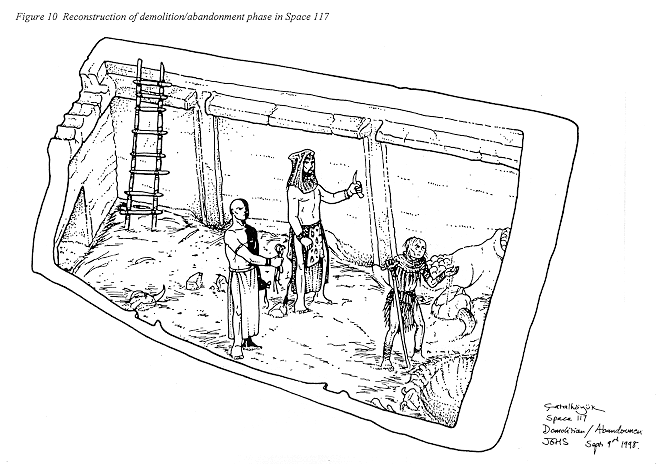
This season's excavation identified a number of phases of activity based upon the dismantlement, erection and re-modelling of features, their uses, and associated deposits (see also Figure 10). Unfortunately progress was slow because of the box-trench excavation technique adopted, and when finally abandoned the excavation of the baulks further slowed work. Consequently by the end of the season, the room was left at different phases of activity.
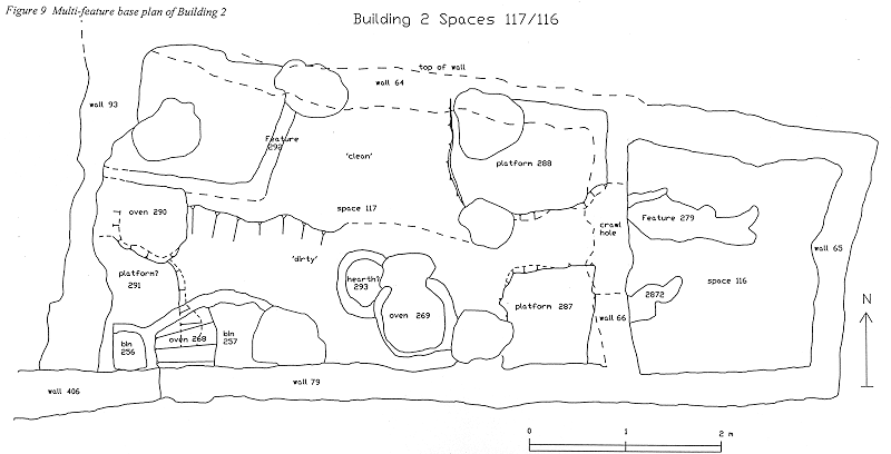
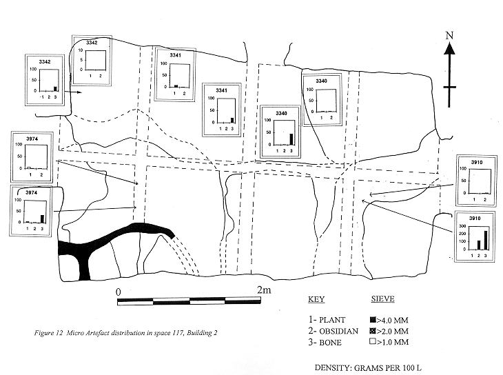
The earliest activity appears to be a brick edged feature 292, located in the north-west corner, with associated floor deposits extending southwards. These floors pre-date 'oven' 290 set within a niche in the west wall, which in turn pre-dates the domed 'oven' 268 in the south-west corner. 'Oven' 268 appeared to be built on top of a feature 291, possibly a platform. Abutting the middle of the south is probably the primary 'oven' 269, which at the current phase was associated with a 'hearth-like' feature 293. A demarcation between the northern half of the room and the southern half was apparent in the contrasting make-up and composition of the floors. The southern half of the room was characterised by accumulative ashy deposits forming compacted floors, derived from oven-use, and the northern half of the room was characterised by 'clean' plaster floors. (Figure 12) The platforms to the east remained constant in form except for the successive re-applications of plaster contiguous with the floor rendering.
The brick edged feature 292 was constructed of re-used fragments of fire scorched bricks up to 0.2m thick set within a make-up deposit [3683/3903]. It formed a roughly square feature, two sides of which were formed by the north and west walls. It is brick edged only and the deposit both within and around looked very similar. This make-up was cut by a posthole [3616] and filled by a homogenous deposit [3615] with a concentration of charcoal flecks both at its surface and basal boundary. Patches of floor [3610], [3670] and [3663] were found in the vicinity but none were continuous or stratigraphically linked to either feature. These were overlain by floors [3617/3605/3608] over which was a make-up layer [3389] and further floors [3342/3341/ 3340] over the top. A small sequence of floors were also excavated last year finally sealed by an organic-rich layer [2024] which represented the abandonment phase through which the structural posts were removed.
To the east below floor [3342/3341/ 3340] was an area of floor [3355], unrelated to the sequence to the west but the same as floors [3913/3926] to the south. This floor sealed a series of successive plaster applications to platform 288 in north-east corner of the room. Renovations to the south-west edge of platform 288 was represented by [3666] which overlay a patch of oven debris [3676], the same as [2795], [2800] and [2819] to south. Unit [3676] represented a further series of successive platform rendering over make-up [3682], over [3696] and [3902].
Successive deposits of make-up and floor deposits were excavated in the south-east corner of the room. The earliest of these was represented by floor make-up [3910], over which an outer rendering [3647] was made for the platform 287 in the south-east corner, and subsequently sealed by floor [3636]. Overlying the floor was a small deposit of re-deposited oven debris [3633]. A further series of floor make-up deposits to the north of 'oven' 269 abutted the outer oven structure represented by [3926], [3913] and [3656], which were sealed by levelling make-up deposits [2798/2797/2793/2753]. The equivalent levelling deposit in the mid-south was [2795/2800/2819/2933], which consisted of crushed oven superstructure material. This sealed the southern 'oven' 269 and 'hearth' 293, filling the shallow cavity over the oven floor but overlying the 'hearth' 293 infill [3917]. Successive make-up and floors associated with the 'oven' and 'hearth' were represented by [3920], [3928] whilst [3946] was a deposit of oven related debris found at its mouth. (Not excavated).
The 'oven' is a horseshoe shaped rim with an opening to the north and a smooth hardened fire-baked floor. In its extant state it would presumably have stood proud and domed, similar to the 'oven' 268 in the south-west corner. It appeared to have had an appendage constructed on its north-west side in the form of a small circular shaped 'hearth' 293. These were raised to floor level at the end of their life-use presumably when 'oven' 290 was constructed in the niche in the western wall 69. Neither of these features have been investigated but it appeared that 'hearth' 293 has been released from associated deposits and is next to be excavated. The interpretation of these features as 'oven' and 'hearth' are tentative and primarily a label to distinguish one from the other. However a distinction is necessary as they would both have had a different function as seen in modern parallels in Turkish villages today.
The levelling deposit over the 'oven' and 'hearth' was overlain by floor deposits [2784/2780] which were contemporary to [2752/2794], the surface of platform 287, and also contemporary with floors [2788/2787/2790], representing the last floors in the room.
In the south-west corner the earliest feature was represented by 291 which was possibly a plastered platform. Only the edges of this feature have been defined as extant later features obscure it. Cutting its eastern edge was a small posthole-type feature [3948], filled by brick-like material [3947]. It has no clear function but its location to the west of the post-retrieval pit [2712] may suggest it to be the location of an earlier post.
Abutting the north face of feature 291 were fired debris deposits [3942], [3941] and [3940] associated with 'oven' 290. This feature has only been half excavated, however its construction and abandonment has been interpreted. The feature was constructed in a cut [3932] with a basal make-up [3931] and a subsequent silty make-up [3919]. Further deposits of plaster [3918] and fire-debris make-up [3914] represent renovations and/or modifications over which part of the superstructure rim [3924] was constructed. A basal foundation floor represented by [3911] lay below the primary 'oven' floor [3691]. Associated floors to this feature were [3680/3681] and possibly [3653].
On the eastern side of the cut were ashy occupation debris, 'dirty' floors associated with oven activity. The earliest isolated patch was [3934] overlain by [3929/3974/3940] and possibly the equivalent to [3355], [3913] and [3910] to the east. Subsequent floor deposits were [3930] below [3922] and below [3916], which was overlain by a strip of oven demolition debris [3912] and probably part of the same deposit [2819] excavated last year. Over the demolition debris a demarcation feature 289 was constructed as a solid plaster lip ([3904], [3901], [3905]) on a north-south alignment west of the area where 'oven' 269 once stood. This probably represented a boundary to contain the 'dirty' area of oven associated deposits from the cleaner area once the earlier oven was no longer used. This then represented a change in activity area in this room; where there was once a 'dirty' area around 'oven' 269 possibly because a 'clean' area at this phase. Floors associated with feature 269 were represented by [3699/3967] and [3681], although neither were directly linked stratigraphically. A shallow depression [3900] was found at this horizon filled by a mixed fill [3695]. It appeared to have formed through wear and may therefore represent a pot emplacement. Sealing it was floor [3673] over which was [3662], a renovation to 289, followed by floor [3653]. Cutting the floor was a possibly posthole [3658] sealed by [3731], a plastery layer excavated as a basal layer of 'oven' 268, but in retrospect, may be part of the 'platform' feature 291.
Abutting the south-west corner of Space 117 was the latest feature, 'oven' 268, constructed as a domed superstructure with an opening to the north. The domed superstructure [3732] was constructed in a cut [3643] with a basal foundation floor
[3606] overlain by the primary oven floor [3383] whilst a post-floor lining [3171], was applied to the internal walls of the oven. Discreet deposits of ash were found on the floor of the oven [3157] and [3147], of which part may have been excavated last season as [2820]. This is uncertain and the loss of this relationship results in the loss of any relationship to the activity at the mouth of the oven and consequently the surrounding area. Apart from ashy deposits [3157] and [3147] there was nothing by way of debris from the use of the 'oven', which suggests it was cleaned prior to infilling. A post-use internal collapse was represented by [3389] over which lay the primary infill [3768]. This was a thin basal layer over which was a more substantial homogenous infill [3137], almost filling the oven to the top. Unit [3136] represented collapse oven lining over the infill and [3132] was collapsed roof. The final deposit was an upper homogenous backfill [3124]. The whole sequence represented a careful and deliberate backfilling event similar to 'oven' 87 in Building 4.
At some stage, the 'oven' was re-modelled but whether it was during use or post-abandonment is not known. The east side of the oven superstructure was cut ([3352]) and modelled into a 'basin'-type feature with a plaster moulded rim [3329]. Later repairs, alterations and rendering were represented by [3328], [3327], [3302], [3315/3309] and [3196/3187]. A section of collapse [3197] was repaired or re-lined [3186]. Further repair to the rimmed wall was represented by [3176]. The 'bin' walls followed the sloped contour of the side of the oven, as if to the maximise the use of heat given off. The 'bin' contained an ashy basal fill [2791] overlain by the predominantly clayball fill [1889], which was subject to long discussions last year.
Contemporary with feature 257 was a similar feature 256 located directly on the roof of the oven. It was a plaster rimmed construction, [3374], [3734] and [3353], within [3354] a cut into plaster rendering [3170] at the top of the 'oven'. As with feature 257 there is no definitive evidence to confirm or dispute contemporaneous use with the 'oven' due to the collapse of the 'basin' base. It is likely that they were used in conjunction unless there was a period when an oven was not necessary in this building, and also because a lot of trouble seemed to have been taken over the construction of both these features. Whether the clayball fill [1889] was connected to the use of these features remains uncertain, but it does seem at odds that a lot of trouble was taken to clean ovens prior to infilling and yet no such attention was given to leaving the basins clean.
Space 116
The feature was not fully excavated this season and despite the careful examination and excavation of up to 58 individual deposits, its form and interpretation remains elusive. It is apparent that a number of elements were deliberately applied and/or moulded to create this formation, with multiple applications representative of modifications, repairs and renderings over time.
A clearer picture should emerge when the base of this feature is reached. However interpretations so far suggest it to represent the collapse of an elaborate 'bin' feature with alterations and extensions as found in Building 5, and an associated work platform on the 'bin' roof, or that it was the remains of one or more wall mouldings.
The identification of owl pellets within deposits overlying this feature is indicative of abandonment and infilling taking place over a period of time, a sequence similar to Space 117. It is therefore crucial to the interpretation of feature 279 to determine whether it represented a primary or secondary feature or deposition in the room.
Space 159
Below erosion and backfill [3126] a deposit of in situ infill was identified stretching evenly across the whole space, heavily disturbed by mole rat holes. This deposit was excavated as [3747/3370/3604] beginning in the north of the as [3370] consisting of mixed material with brick and plaster aggregates and [3604] and [3747] representing the same deposit to the south of the space. An area of in situ floors was located towards the centre of the space seemingly within the infill deposits.
Overlying the northern edge of the floors was a discreet ashy deposit, unlike the type found in 'midden' deposits as there were no charcoal inclusions; consisting almost entirely of pure pale grey ash with largish fragments of pale brown brick. This was a localised deposit within the infill sequence, but notable because of the discovery within it of a bear claw [3603]. The extent of this ashy material was therefore isolated and excavated as [3641]. Despite the novelty value of the bear claw and the more detailed attention given to the excavation of the deposit, it did not yield any further or more information about the origins of the deposit and further excavation revealed a further infill [3714] that lay immediately above the floors.
The floors survived in an area measuring the width of the space and with a length of only 1.1m. In an attempt to locate the continuation of the floors a small sounding was excavated in the south-east corner of the space to the total depth of the walls. This however revealed a continuous, homogenous deposit of infill, in appearance the same as [3747/3370/3604], and with no sign of banding or possible floors. Unusually the whole depth of the wall was completely plaster rendered, a feature which usually identifies the location of the floors.
The floors were excavated in six layers of multiple laminations of plaster and packing. Micro-morphological block samples taken from these deposits which should identify the micro-stratigraphy. The earliest floor horizon was [3965] overlain by [3958], [3796] and [3795] respectively. Cutting [3795] were two features, which have provisionally been interpreted as postholes. Cut [3784] was located against the west wall, semi-circular in plan measuring 0.58m x 0.4m x 0.2m deep. Filled by [3783] and [3779], which was a mixed fill with fragments of brick and plaster inclusions. Opposite, against the east wall was a similar shaped, but slightly smaller in size, cut [3786] filled by [3785], a similar infill of mixed building debris. These were sealed by later floors [3759] and [3758] respectively.
The location of the floors roughly coincided with the location of the access route between the 'ante-chamber' and Shrine 10. This location may be relevant to the presence of floors, which may be due to subsidence in an area of heavy traffic. It would therefore be possible that the excavation of the level VII floors in the '60's excavation missed this area of floors because of its sunken nature. The infill immediately above the floors may therefore represent level VI infill.
Space 160
Below erosion and backfill [3126], layer [3179] was excavated which defined the area of Space 160 which was found to be smaller than at first defined. Below [3179], which was a heavily disturbed layer, a hitherto unseen south wall was defined c. 0.6m further north than the southern limit of the space as first defined, a 'doorway' in the south-west corner. The north and west limits were defined by walls but the east appeared to be an arbitrary section left by the previous expeditions work.
An infill deposit [3191] was excavated consisting of a very hard clayey matrix with fragments of mudbrick and plaster inclusions. This was excavated to a level just above what appeared to be floor layers in the east section. Layer [3343/3344] was excavated in two sections for sampling reasons, over the top of this layer was a group of horizontally laid pottery sherds apparently crushed in situ, which it was found to form a complete profile. The excavation of this layer however revealed a comparatively sterile hard clay layer with all the appearances of infill as opposed to an occupation deposit. Similarly underlying deposits (from the bottom up [3709], [3703] [3620] and [3379]) were of similar composition. After excavation however, the section in the 'doorway' revealed these deposits as banded horizontal layers, which, combined with the discovery of the horizontally lying pottery sherds over [3343/3344], may indicate a floor horizon, a type not previously identified. During the excavation of [3703] an east wall was defined, the location of which coincided with what appeared to be the base of the previous walls.
It is possible that the level VII floor ([3343/3344] and [3379]), having been identified as a change, was excavated without correct interpretation. The unusual character of these floors may be indicative of this type of room and use as, in Mellaartian terms, 'entrance shafts'. Quite clearly Space 160 is not a stand-alone building and the building to the south needs to be excavated in order to understand it.
Walls And Phasing
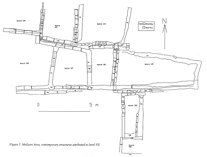
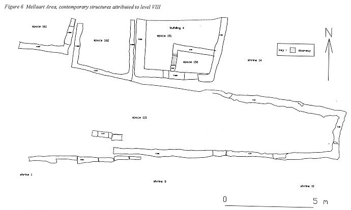
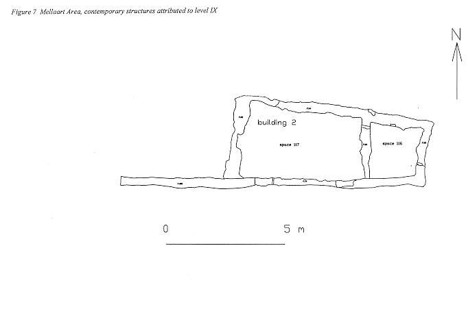
Three main structural phases of activity have been defined in the areas investigated in the Mellaart area so far (Figure 5, Figure 6, Figure 7). These reflect a continuity of structural space with little or no room for expansion due to the spatial restrictions imposed by neighbouring structures. The earliest building to date is Building 2, attributable to Mellaart's level IX (Figure 7). It was infilled and used as an open 'midden' area, Space 115, attributable to level VIII (Figure 6) and contemporary to the northern buildings, Space 161 (below Space 109), Space 162 (below Space 112) and Building 4 (below Space 113). Mellaart Shrines 1 and 8 bounded it to the south. Eastwards it extended over Building 2 and to the west it continued beyond the limit of excavation.
In the succeeding phase, level VII (Figure 5), the area was re-developed and structures represented by Spaces 106, 107 and 108 were constructed. The external 'midden' area reduced in size to Space 105 and was contemporary to Spaces 109, 112 and 113 to the north and Mellaart's Shrines 1 and 8 to the south.
The excavation of the walls at the junction of Buildings 2 and 4 and Spaces 114 and 115 recorded up to eighteen segments of wall, the analysis of which have unravelled some of the problems of phasing at this junction. It is not the purpose to record each event here but to elucidate a few interesting points.
Wall 58 was the east wall to Space 106. Investigation this season revealed wall 282, the north wall of 106, which currently appeared to be a continuous construction. In turn wall 282, appeared to be a continuation of wall 286, the south wall of Space 112. This implies that a 'dog-leg' construction of walls (wall 267, west of Space 112, wall 286, south of Space 112, wall 282, north of Space 106 and wall 58 east of Space 106) was erected prior to the construction of the walls to Spaces 107 and 108. This is by no means the end of the sequence but the beginning of understanding the chronology of this 'neighbourhood' as opposed to the construction and use of buildings in isolation.
Wall 56, the west wall of Space 105 was later than wall 58. It was constructed in a 'foundation trench' [3305], representing a relatively elaborate form of construction for Çatalhöyük. The wall and infill of the foundation trench were raised concurrently. This was carried out in a sequence by the laying of two or three brick and mortar courses followed by a deposit of infill. An advantage in this form of construction would be to elevate the builder for ease of construction and reach, but equally may have resulted in a more consolidated structure, particularly as the north-south aligned walls were prone to slumping. One of the questions that arose during the excavation of this wall was what the necessity of a 'trench-built' wall was? By the time of the construction of Space 105, the walls to the underlying building, Building 2, were completely buried under 'midden'. It is possible therefore that the cut was made in order to locate the earlier wall. An explanation for this was probably to ensure a stable 'footing' for the construction of the later wall 56. It could also reflect a more ritually significant role, that of the 'ritual connection' to an 'ancestral' property, or, to define a property boundary which has a more social organisation implication.
Discussion
One explanation could be related to the burial practices of the Neolithic people. In order to continue the practice of multiple burials beneath floors the deposits to contain the burials had to be topped up. This however does not explain the end of buildings where there were no burials. There may of course have been multiple objectives for the 'end' of a building including the death of a family head, practicalities of space or sanitation.
Certain trends are emerging as to the treatment of a building at the end of its life-use.
The majority of buildings appeared to have been deliberately infilled. New walls and floors constructed, usually over prepared level horizons probably for practical constructional and consolidation purposes. The east-west aligned walls were generally stepped in imitation of the site terracing and the north-south aligned walls more elaborately constructed or added to for further support. It is not always clear whether the infill was laid prior to or post-the construction of the new walls.
Infill deposits were the topic of discussion for many priority tours. The recognition of variations within infill, discard, dumps, midden and refuse deposits led to discussions on the source of these materials and the function of specific types and uses of.
Buildings were deliberately infilled with what may be imported material, usually with characteristics of screened material. In matrix it differs from deposits under excavation but could it be the end product of screened roof and/or wall debris which is missing in the archaeological record? If screening did take place its function must have been associated with the construction of the next building as no similar deposits were found in the abandoned Building 2. Screened material would have functioned as a better foundation deposit needing little or no time to settle; whereas dumps by nature would require a settling period as organic matter rotted and reduced causing subsequent movement and subsidence. The fine graded infill may therefore have been a foundation raft.
This explanation may also address the question as to why so much care was taken to preserve features such as ovens and bins at the end of the life of a building. Evidence indicates a deliberate and careful cleaning process prior to infilling from the mouth of 'oven' features not a more convenient hole made in the roof. The preservation of certain features was clearly of importance, which is at odds with the treatment of other areas of the building where floors suffered heavily from scouring and post-retrieval events.
Comparative sequences were excavated in 'oven' 268 in Building 2 and 'oven' 11 in Building 1. 'Oven' 242 in Building 5 however diverges from this trend. Was the preservation of certain features connected to a belief in ancestral afterlife, or a more practical exercise? Similar to building infilling may the reason for infilling features also relate to practicalities linked to the construction of the subsequent building?
Other buildings, such as Building 2, were abandoned. Was this abandonment planned and pre-targeted as waste or common ground? The infill of this building appeared to consist of primary refuse deposits which had to collect somewhere, or, was the building abandoned and whilst falling into disrepair, utilised as a waste disposal area.
What was the significance of the change in type of refuse deposition in Space 115 once Building 2 was levelled? Eventually the area was re-developed. While 'external' area was reduced in size it was still used for rubbish disposal indicating the continued necessity for this type of spatial use.
Figure 5 Mellaart Area, contemporary structures attributed to level VII
Figure 6 Mellaart Area, contemporary structures attributed to level VIII
Figure 7 Mellaart Area, contemporary structures attributed to level IX
Figure 8 Multi-feature base plan of Building 4
Figure 9 Multi-feature base plan of Building 2
Figure 10 Reconstruction of demolition/abandonment phase in Space 117
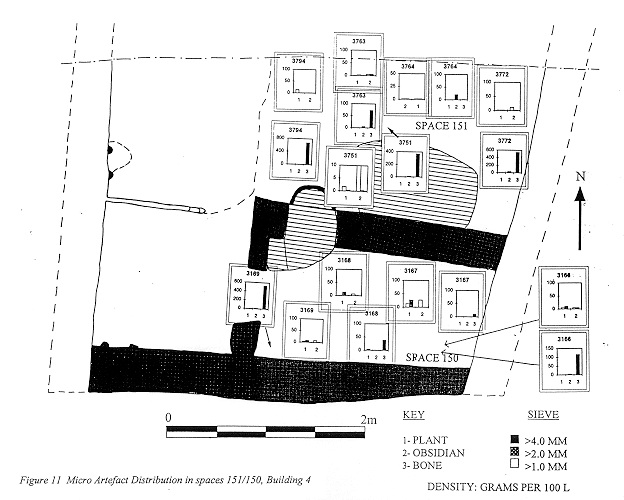
Figure 11 Micro Artefact Distribution in spaces 151/150, Building 4
Figure 12 Micro Artefact distribution in space 117, Building 2
| |
© Çatalhöyük Research Project and individual authors, 1998