ÇATALHÖYÜK 1995 ARCHIVE REPORT
    |
Çatalhöyük 1995: surface scraping
R.J. Matthews
Due to the emphasis on excavation, a limited amount of surface scraping was carried out this season. In total three 10 by 10 m squares were exposed, all in the North Area where work in 1993 and 1994 had produced clear and meaningful results, showing the presence of almost completely undisturbed Neolithic buildings immediately underlying the modern mound surface. As in previous seasons the methodology employed involved firstly the removal of surface vegetation and the recovery of all visible surface artefacts. Next the top few cm of soil were removed by pick and shovel, and the resulting surface then cleaned with wide-bladed hoes, all artefacts again being kept. Any visible features - walls, pits, burials, ovens, ash spreads - were planned at 1:50. Detailed information on walls - brick size, presence of plaster etc - was then recorded on special forms.
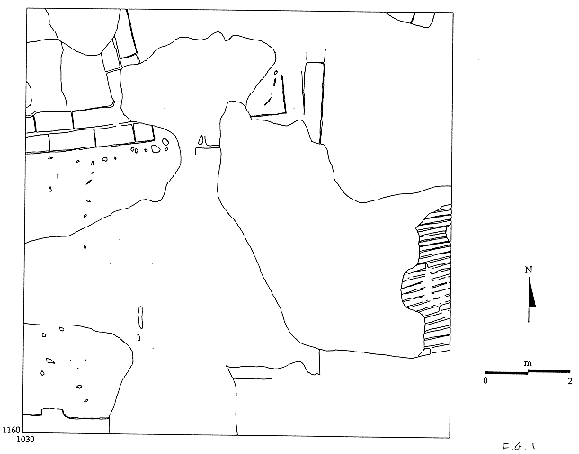
Square 1030/1160 (Fig 1) was exposed in order to follow the probable street or corridor which had previously been detected, running along the W edge of a large complex of buildings. This street runs for a short distance into 1030/1160 before being obscured by a large ashy pit and a stretch of collapsed wall. To the W of the street lengths of typical Neolithic double walls were clearly visible. Much of the central and S part of the square is disturbed by extensive spreads of ashy matter at least some of which appears to be in a pit. Brick fragments and pottery sherds from this area of the square suggest a Roman or Byzantine date for these ash spreads. In the extreme SW corner of the square a short stretch of Neolithic wall survived, with clear white plaster on its N face. In the middle of these plaster applications a strip of pinkish-red paint was detected.
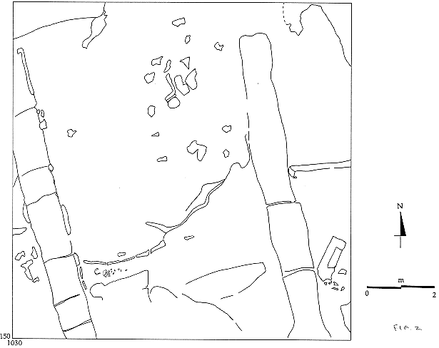
Cleaning of the next square to the S, 1030/1150, exposed the remains of a substantial building (Fig 2) Brick sizes, the presence of brick-lined graves and the types of pottery found here all indicate that this building is of Roman or Byzantine date. The building comprises a long room, of which three walls are visible. The walls are much more massive than Neolithic walls and built of smaller bricks, although visibility of individual bricks was not good. The N wall of the room clearly cuts across the Neolithic wall in the SW corner of 1030/1160. At least two burials, aligned SW-NE, are located within the building. a brick-lined burial carefully respects the E wall face of the main W wall of the room, suggesting that this burial was probably dug into the foundation of a building from a floor surface which no longer exists. All the indications are that, as it now survives there is very little depth remaining of this Roman-Byzantine building. The presence of the building provides a context for the accumulation of ashy rubbish which have disrupted the Neolithic architecture to the north.
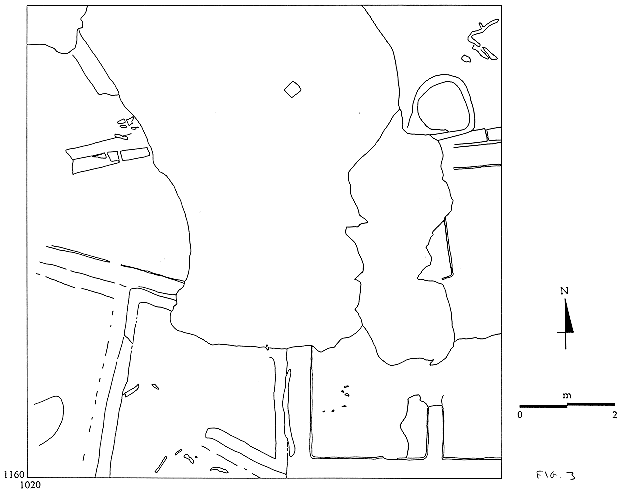
Moving to the NW, clearance of square 1020/1160 (Fig 3) again revealed intact Neolithic structures to some extent disturbed by later ashy deposits. The N and central areas of this square consisted of further spreads of ashy debris in pits, again of Roman-Byzantine date as attested by pottery and fragments of terracotta tiles. In the NE part of the square intact Neolithic remains were clear, including a double plastered wall and a circular fire installation. A series of Neolithic rooms lay along the S edge of the square, with several pairs of plastered walls, on with an associated cattle horn.
In sum the limited quantity of surface scraping conducted at Catalhoyuk during 1995 has continued to reveal extensive Neolithic architecture lying immediately under the modern mound surface, increasing our plan of a large complex of building investigated in earlier seasons. To the S we have now detected substantial later occupation n the form of a Roman-Byzantine building with associated burials and rubbish deposits.
| |
© Çatalhöyük Research Project and individual authors, 1995