ÇATALHÖYÜK 1995 ARCHIVE REPORT
| |
Introduction
Ian Hodder
Renewed research at Çatalhöyük began in 1993. The 1995 season completes the first phase of research in which the aims have been as follows. (i) To find out as much as possible about the site as a whole without excavation. This has involved geophysical prospection, surface collection and scraping and topographic survey. In 1995 the aim was to carry out a topographic survey of the west mound and to continue surface scraping on the north part of the east mound. (ii) To develop conservation strategies for the mud plaster paintings and sculptures. In order to allow research and experimentation with consolidation strategies, the aim in 1995 was to excavate on the north part of the east mound. Excavation was to be restricted to a small area so that conservation research could be carried out without causing severe conservation challenges until preliminary research had been completed. (iii) To clean an area at the base of the 1960s excavations in readiness for excavation of the unexplored lowest levels of the site. Since coring has revealed 5m of occupation below the lowest level (XII) reached in the 1960s, the aim is to clear a 20m x 20m area of exposed walls and erosions so that safe excavation can begin of the lowest levels.
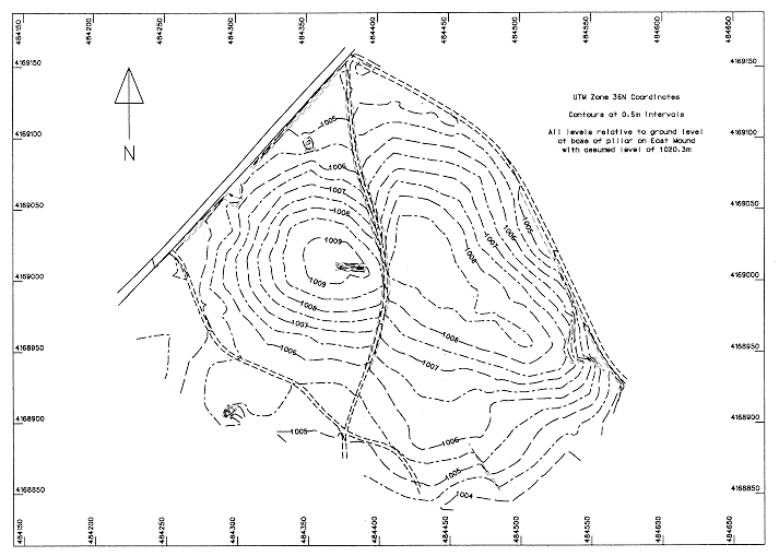
The surface of the West mound was mapped using a high precision Leica 200 Global Positioning System operated by Dr David Twigg from Loughborough University (see figure 1). The topograph survey of both mounds is now complete, allowing the plotting of surface data onto the contour maps (eg see figure 2 showing obsidian densities). Geophysical prospection on the East mound was completed by Dr Colin Shell, University of Cambridge.
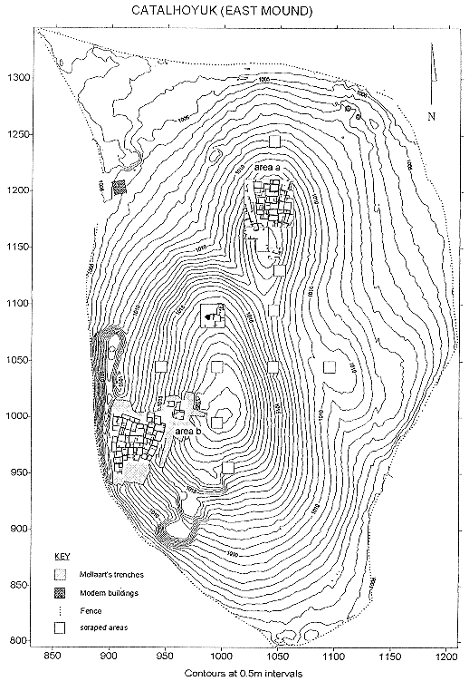
Regarding excavation, on the northern eminence (area a in figure 3) a shelter was constructed over Building 1 and excavation concentrated in Space (room) 70, although excavation also began in parts of Space 71. In the Mellaart area (area b in figure 3) a 20m x 20m square was cleared of vegetation, eroded fill was cleared from rooms and intentional backfill into the 'deep sounding' was cleared to a depth considered safe until further removal of walls has been achieved. All exposed sections were recorded and excavation began in Courtyard 15 and House 2.
Recording of the excavation on the northern eminence was achieved using an EDM with reflectorless laser. Coordinates of artifacts and plans of features were entered directly from the EDM into a GIS database.
Construction commenced of the dig house on the northern edge of the fenced area. Three laboratories have been constructed and work has begun on a further wing of the building. One of the laboratories has been used as a depot, and another houses a display of panels and posters which can be shown to visitors to the site. The site guard has access to the building.
In addition to the work on the east and west mounds, other projects included geomorphology (directed by Dr N Roberts), regional survey (directed by Dr D Baird), excavation at Pinarbasi (directed by Dr T Watkins), ethnoarchaeology (conducted by N. Yalman) and social anthropology (conducted by Dr D Shankland).
The project is extremely grateful to the Ministry of Culture, General Directorate of Monuments and Museums, and to their representative Mr Ali Ondah, for their help and support. Assistance was also given by Ilhan Temiszoy, Director of the Museum of Anatolian Civilisations at Ankara, Konya Museums (Director Erdogan Erol) and the Cumra Belediye Baskan. An enormous amount of logistical help and advice was provided over the year by the Acting Director and staff of the British Institute of Archaeology at Ankara, to whom we are extremely grateful. Funding for the field research was provided by the British Academy, the British Institute of Archaeology at Ankara, the McDonald Institute, the European Union and the National Geographic Society.
| |
© Çatalhöyük Research Project and individual authors, 1995