ÇATALHÖYÜK 1994 ARCHIVE REPORT
    |
Analysis of Field sections from the 1960s' excavations
Wendy Matthews
1. Introduction
In the second season of renewed investigations at Çatalhöyük a total length of ca. 47.5m of field sections from the 1960s'excavations, 161.8m2 in area, was cleaned, photographed, drawn at 1:20 and described, in the central and southern sectors of Area E (Figure 1). These sections, numbered 6-9, have been correlated with plans of Levels XII-V published by Mellaart in his preliminary reports and general book (Mellaart 1962, 1963, 1964, 1966 and 1967). Selected areas of these sections were in addition drawn at 1:5, described in further detail and sampled for micromorphological, chemical, conservation and pollen analyses.
During the last two seasons, therefore, a total length of ca. 98.5m of field sections from the 1960s'excavafions, 336.8m2 in area, has been studied. The objective is to record the sections before further erosion, and to study the architecture, occupation sequences, and structure of the site, before new excavations begin in 1995.
The sections were cleaned, drawn and recorded by Dr Wendy Matthews, Nurcan Yalman, Nurcan Kayacan, Ali Türkan, Bekir Gurdil, Naomi Hamilton, Dr Charles French and Kasia Gdaniec.
This preliminary report is divided into the following parts which discuss:
- Section conditions, cleaning and recording.
- Sampling for micromorphological, chemical, conservation, pollen, experimental and comparative analyses, and the preliminary results from the micromorphological and pollen analyses.
- Correlations with features and levels identified during the 1960's excavations.
- Site structure, including analysis of the architecture, phasing, terracing, nature of floors and occupation sequences, infilling, and the area represented by different contexts in field sections.
1.1. Section conditions
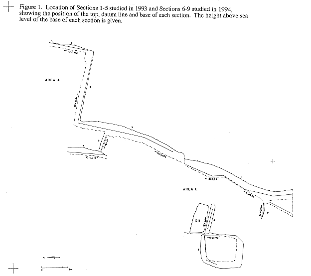
The sections in the central and southern sector of Area E currently rise in stages to a height of 8.55 metres, from 1004.35 - 1012.90m a.s.l., and are not as well preserved as those in the northern half of Area E and in Area A which were studied in 1993. The main eastern section of this area, Section 7, currently covers 6.27 metres of stratigraphy from the banks of collapsed debris at its base, 1006.63m a.s.l, to the top of its grassy surface at 1012.90m a.s.1. (Figure 1 and Figure 5). Section 6 is in the centre of Area E. to the west of Section 7, at right angles. Section 6 is 3.05 metres high, from its base on the extant floor surface of Level XII Building 25 after cleaning, at 1004.35m a.s.l., to its top at 1007.40m a.s.1. (Figure 1 and Figure 2). There is an overlap in absolute height between Sections 6 and 7 of 0.77m.
The banks of collapsed debris at the base of Section 7 were not removed for reasons of safety. It can be estimated that the original base of Section 7, which was also excavated down to Level XII by Mellaart, now lies buried below some 2.28 metres of collapsed debris.
Much of this debris comprises collapsed mud brick and wall plaster. In many instances Mellaart excavated up to the wall faces in each building unit. This is clearly illustrated in a photograph of the northern part of Section 7 which was taken in 1965 where the section principally comprises mud brick walls (Mellaart 1966, Plate XXXI (a)). These walls have since eroded and fallen away from the section face to expose the wall plaster and room fill of previously unseen and unexcavated buildings. The northern section in the centre of Area E which faces south, adjacent to Section 7, was not studied because ashy deposits at its base have eroded at a faster rate than later walls, and undercut the section.
The tops of each section have eroded back approximately one metre from the line of the base of the section (Figure 1), the section faces are sloping and irregular.
1.2. Section cleaning
The northern half of Section 7 was not cleaned due to its great height and potential instability. The remaining sections were all photographed before cleaning to record the condition of the eroded section face. The thin skim of silty wash which covered most of the section faces was gently removed by trowel, plasterer's leaf blade and artist's palette knife before final cleaning by air from a pair of bellows. The banks of eroded material at the base of these smaller sections were removed by shovel and trowel, and the exposed section face cleaned. Only 25cm of eroded material had collapsed onto the floors of Level XII.25 in front of Section 6. This collapsed debris was removed with care by shovel and trowel, down to the first layers of water-laid rainwash ca. l cm thick which had accumulated after excavations ceased in 1965. These water-laid layers were removed to expose the extant floor surface. After the sections had been studied, earth was banked back up against the sections to prevent further erosion.
1.3. Section recording
All of the sections were photographed and drawn at 1:20. Each stratigraphic unit was described recording Unit number, moisture, Munsell colour, structure, texture; inclusion type, size and abundance; interpretation and any additional comments.
Although the northern half of Section 7 was not cleaned due to its great height, many individual mud bricks, walls, plaster faces, floors and pits were distinct enough to enable drawing at 1:20 and photography. The outline of the top and bottom of the section, and a datum line were measured using an EDM. Ranging poles, two metres in length with 50cm markings, were set both vertically and horizontally along the base of the section to enable details to be measured accurately by eye and drawn from a distance.
Floor sequences in each of the sections were photographed in close-up, drawn at 1:5, and described in greater detail in order to record the microstratigraphy of activity areas.
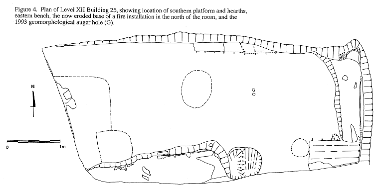
The three-dimensional location of all sections was recorded and planned in Figure 1. The re-exposed features of Level XII.25 were also planned and three-dimensionally recorded, Figure 4.
2. Sampling
2.1. Micromorphology
2.1.1. Method
20 samples were collected for analysis in large thin sections, 13.5 x 6.5cm. After the field sections had been drawn and recorded, block samples of floors and occupation deposits, ca. 13.5 x 6.5 x 9cm, were cut out of the section faces with a Swiss Army knife and small saw. These blocks of sediment were wrapped tightly in laboratory tissue and tape, and air dried on open shelves. They were packed into wooden boxes which were examined by the Turkish Department of Antiquities in Konya and sealed with lead and wire for export. The samples were driven back in the vehicle space kindly provided by Warren Eastwood and Dr Neil Roberts of the geomorphological team at Çatalhöyük.
In the Department of Archaeology, University of Cambridge, the samples were oven dried at 30-40C then impregnated with an unsaturated crystic polyester resin which takes six weeks to harden. The thin sections will be ready for analysis in the spring of 1995. The micromorphological analyses at Çatalhöyük are part of a three year research project supported by the Natural Environment Research Council at the McDonald Institute for Archaeological Research, University of Cambridge. The aim is to develop the application of micromorphology to the study of occupation sequences and use of space in early urban sites in the Near East. The project is being conducted by Dr Wendy Matthews, Research Associate, Dr Charles French, Lecturer in Geoarchaeology, and Professor Martin Jones, Professor of Archaeological Science at the McDonald Institute for Archaeological Research, University of Cambridge, and Dr David Cutler and Mr Tim Lawrence of the Plant Anatomy Section, Jodrell Laboratory, The Royal Botanic Gardens Kew. The cellular structure of desiccated, silicified and charred plant remains is often well preserved in thin-section enabling study of the anatomy, preservation and use of plants.
The other sites in the project are Tell Brak in Syria, 3,600-1,600BC, and Saar in Bahrain 2,000-1,800BC. Micromorphological samples from the Aceramic Neolithic site of Asikli Höyük, Aksaray, Turkey, are also being studied. These were collected by Fusun Ertug with the kind permission of the Director of excavations Professor Ufuk Esin, Istanbul, and exported with the permission of the Turkish Department of Antiquities through the Aksaray Museum in 1994. These samples are from a storage area and an open area which has deposits rich in charred plant remains and phytoliths.
2.1.2. Preliminary analysis of thin section samples collected in 1993
The preliminary results from micromorphological analysis of the samples collected in 1993 are discussed below. The NERC project will be completed in July 1996. The thin sections are studied under optical polarising microscopes at magnifications of x5 - x400, using a large field Wild Photomacroscop and Nikon Optiphot with fluorescent light attachment.
Architectural materials
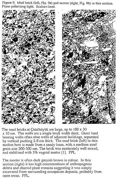
Mud bricks (Figure 9a)
The mud brick source materials were moderately well pugged and compacted. They were stabilised with up to 5% vegetal matter, which is now only attested by the pseudomorphic voids in the sedimentary matrix. The sandv loam mud bricks have a medium sand grain size, 200-300,um.
Mortar (Figure 9b)
The mortar is often dark greyish brown in colour. In thin section it has high concentrations of anthropogenic debris, such as burnt aggregates, bone fragments and charred plant remains suggesting it was simply excavated from surrounding occupation deposits, probably from unroofed areas. The microstructure has irregular voids, classified as vughs, which probably originate from air trapped during the digging up of unroofed area deposits and rough remoulding as mortar between the bricks. Both this expedient source material and the vughy microstructure of this mortar at Çatalhöyük are characteristic of mortars studied in thin section from the Sumerian city of Abu Salabikh in southern Iraq, ca. 2,500BC, suggesting that the architectural technology employed at Çatalhöyük was both effective and practicable.
Occupation sequences and use of space
There are four principal stages in analysis and interpretation of occupation sequences in thin section:
- Firstly, it is possible to characterise the nature and technology of different floors.
- Secondly, the impact of different activities on surfaces can be assessed, such as trampling or the use of mats or rugs.
- Thirdly, it is possible to study the depositional and contextual relationship between sediments, artefacts and organic or inorganic remains such as plants, bone or shell.
- Fourthly, it is possible to identify naturally laid deposits or any post-depositional alterations.
We are then able to study the type, thickness, frequency and microstratigraphic sequence of floors and occupation deposits in different activity areas and rooms both in the large thin sections and in the 1:5 section drawings (Matthews and Postgate 1994).
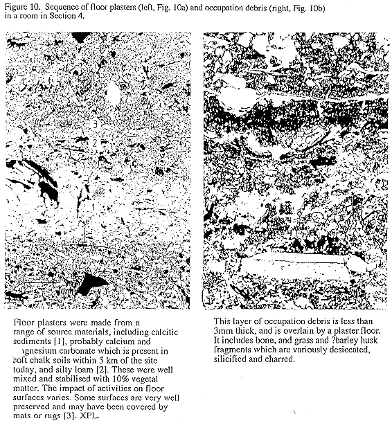
Floor plasters (Figure 10a).
Floor plasters were made from a range of source materials, including calcitic sediments probably calcium and magnesium carbonate which is present in soft chalk soils within 5 km of the site today and silty loam. These were well mixed and stabilised with 10% vegetal matter, which has since decayed and is represented by pseudomorphic voids in the microstructure of the surrounding sediments.
Impact of activities on floor surfaces
The impact of activities on floor surfaces varies. Some surfaces are very well preserved and were probably covered by mats or rugs, others are more irregular and disturbed by trampling.
Occupation deposits (Figure 10b)
Many floors were kept very clean with little build up of occupation deposits between each layer of plaster. Although accumulations of occupation deposits are often less than 3-5mm thick, it is possible under the microscope to identify activity residues such as plant and bone fragments, and to piece together the depositional evidence for the activities which took place in different rooms and areas of the buildings at Çatalhöyük. In a room from Level VIA in Section 4, Kew have identified a range of plant remains from only a preliminary examination of one slide. These preliminary identifications are listed here to illustrate the potential range of observations from study of plant materials in thin section. Interpretation of the preservation, use and deposition of these plant materials awaits further anatomical and species identifications by comparison to reference materials, quantification by image and area analysis, and analysis of the contextual associations of the plant materials and other depositional components.
| Charred | ||
| Oak | Quercus | earlywood and latewood, TS+LS |
|
Conifer |
wood, OLS | |
| Angiosperm | ridged stem, TS + LS | |
| Monocotyledon | stem, TS (many) | |
| Dicotyledon, ?willow/poplar | ?Salicaceae | wood, TS |
| Flower/fruit | seed, LS | |
| Uncharred, Silicified/desiccated | ||
| Grass | phytoliths | |
| Grass, possibly wheat/barley | husk epidermis |
TS: Transverse section. LS: Longitudinal section. OLS: Oblique longitudinal section.
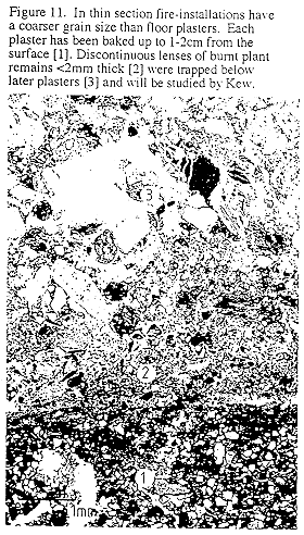
Fire installations
The hearths and ovens at Çatalhöyük (Figure 11) were frequently cleaned out and re-plastered. Each plaster was baked up to 1-2 cm below its surface. The heat has charred many of the vegetal stabilisers within the plaster fabric and has preserved the anatomy of these plant remains, many of which are grass leaf and husk fragments. Vegetal stabilisers in total constitute up to 10% of the plaster fabric. Hearth and oven plasters have a coarser grain size than floor plasters. Burnt fuel and food remains which had not been completely cleaned out when the fire installation was replastered, only survive as discontinuous lenses <2 mm thick, trapped between separate layers of plaster. These plant remains are also being studied by Kew, and include coniferous woods and oak wood.
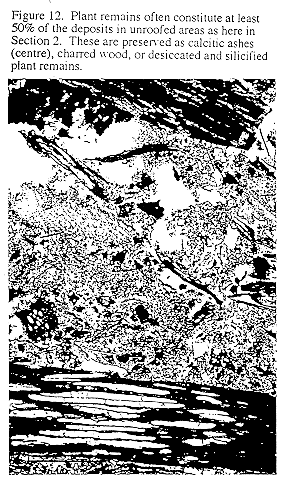
Unroofed area
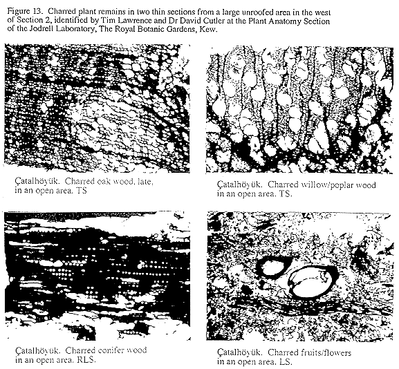
Unroofed areas between buildings (Figure 12 and Figure 13) had thick accumulations of burnt rubbish, rich in charred plant remains and bone, several metres deep, by contrast to rooms and fire installations, from which presumably most of the deposits in these areas are derived. Within two thin sections, each 13.5 x 6.5 cm, from the open area in Section 2, Kew have made the following preliminary identifications:
| Charred | ||
| Oak | Quercus | includes latewood + earlywood, TS, TLS |
| Willow/poplar | SalixlPopulus | wood, TS, OLS |
| Coniferous wood | wood, RLS, TS and LS | |
| Dicotyledon | wood with tall rays, TLS wood with narrow rays, TS wood with coarse intervascular pits, LS |
|
| Reed | probably Phragmites | stem with annular/spiral thickenings culm ?leaf sheath |
| Fruits/flowers | seeds | |
| ?Dung | ||
| Partially charred | ||
| Monocotyledon | epidermis with papillae epidermis with thick sinuous cell walls epidermis with short cells root |
|
| Fibrous strand | ?dyed red, with tracheary elements |
Lenses of orange-brown amorphous organic staining are clearly visible in thin sections of unroofed area deposits, and suggest that chemical analyses for organic residues will be rewarding.
2.2. Chemical analyses
14 samples were collected for comparative chemical analyses of, in particular, phosphate, organic residues by gas chromatography and mass spectrometry, and calcium carbonate.
2.3. Conservation
Four samples of plaster have been sent to Professor Frank Matero, Director, Architectural Conservation Laboratory, Graduate School of Fine Arts, University of Pennsylvania, Philadelphia for laboratory analyses prior to the first season of field assessment and conservation in 1995.
2.4. Pollen
Nine pollen samples were collected in 1994 for comparison to the results from 1993. The samples from 1994 were collected from floors in Level XII.25 and Level VIII.25; open area deposits in Level IX and XI, and mud bricks from these same levels for comparative purposes.
The samples from 1993 were analysed by Warren Eastwood, a member of Dr Neil Robert's geomorphological team, at the Palynological Research Centre, Institute of Earth studies, University of Wales, Aberystwyth. The pollen grains were identified and counted using a Nikon Labophot-2 microscope at x100, x200 and x400 magnification. Critical identifications were conducted under oil immersion at x1000 magnification using the key in Pollen analysis (Moore, Webb and Collinson, 1991). Plant nomenclature follows Clapham, Tutin and Moore 1987, while pollen typology follows Moore et al 1991. The presence of charcoal fragments is also indicated. The 'indetenninate' category includes grains which are crumpled, broken or obscured.
The results are listed in Table 1. Unfortunately the pollen grain concentrations on the whole are very low, and interpretations limited. Most of the samples were very minerogenic and required prolonged Hf treatment.
2.5. Experimental and comparative analyses
13 samples were also collected from the base of a buried river channel close to the site of Çatalhöyük, soft lime deposits within 4km of the site, and modem chaff, dung and ash for micromorphological and chemical analyses for comparison to analysis of the Neolithic mud brick and plaster source materials, and ashy deposits in occupation sequences and unroofed areas.
3. Correlation of sections with plans from 1960s' excavations.
It has been possible to correlate the section drawings with plans from the 1960s' excavations by analysis of room size, walls, settlement layout and published descriptions of each building unit and level. Plans from both the preliminary reports and the general book were reproduced at uniform scales on transparencies and overlain in order to reconstruct the series of building levels excavated by Mellaart. The aim in this section of the report is to correlate the features observed during section cleaning with the buildings and levels identified by Mellaart during excavation. These correlations are based on the evidence available to us and may be revised after forthcoming discussions with Mellaart. The structure of the site is analysed below in the final part of this report.
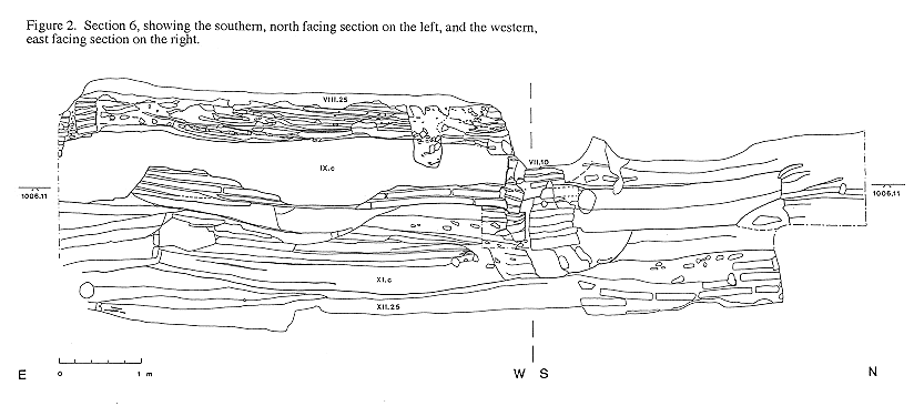
3.1. Section 6
Section 6 (Figure 2, figure 3, figure 4) has two conjoining faces, facing north and cast. The north facing section starts 5 metres west of Section 7 and has been securely correlated with features from Building 25 Levels XII-VIII. Pick marks from Mellaart's Excavations were uncovered during cleaning of the section face in levels VIII, XI and Xll. The surrounding buildings, numbered 27, 10, and 14, and unroofed area 15, were not excavated by Mellaart below Level VIII and still have remnants of walls which can be clearly traced on the ground and correlate with his plan of Level VIII (Mellaart 1966, Fig.7).
Level XII
The plan of Level XII 25 was re-exposed by careful cleaning (Figure 4). The walls and features correlate closely with Mellaart's plan (Mellaart 1966, Figure 3). There is a platform on the south side, a bench on the east side and an eroded hearth in the north of the room. Two circular hearths with ashy fill still in-situ were uncovered immediately below laminated layers of rain washed silts and sands at the eastern edge of the platform. These two hearths were not recorded by Mellaart and may have been exposed after 1965 by erosion. The floor surface was uneven, sloping down to the west, and consisted of interbedded lenses of red pigmented plaster, white plaster and ashy flecks. The small circular hole from geomorphological augering in 1993 was uncovered. It cuts through the extant floor surface of Level XII at 1004.46 a.s.1.
Plate XXXII (a) in Mellaart 1966 suggests the northern wall of XII.25 is more curving than indicated on Mellaart's original plan (Mellaart 1966, Figure 3), and follows the line drawn in Figure 4. The outer faces of the northern and the eastern walls currently lie protected below collapsed debris and were not uncovered because the exposed wall faces were not well preserved. Only the inner face of the western wall was excavated and exposed in 1965 and survives in the east facing section the outer face lies below unexcavated levels to the west. Nothing of the southern wall of Level XII.25 has vet been exposed either by excavation or erosion. The southern extent of XII.25 therefore is not yet known.
3.1.1. Southern section, North facing (Figure 2)
In the section there is a layer of collapsed plaster and building debris, 30-70cm deep, on top of Level XII.25 floor.
Level XI
The 1.1 metres of ashy deposits which overly Level XII have been correlated with the Level XI "Court" excavated by Mellaart (Mellaart 1966, Figure 2). The layers are thin and of varying composition, and probably accumulated over a period of time in an unroofed area rather than as a single depositional event such as infilling or levelling.
Level X
The mud brick wall which was constructed on top of Level XI could not be correlated with any building or feature excavated by Mellaart. He did not uncover any walls at this level during excavation:
"In Level X the area of rooms 25 and 28 was one large courtyard and at first it looked as if a change of architecture had taken place in this area. However, when the courtyard was removed, buildings appeared again in Level XI and XII with the same orientation as those of Levels IX-VI, so that the possibility of a break can be discounted."
(Mellaart 1966,168).
The fragmentary wall uncovered during cleaning of Section 6 most probably belongs to Level X. This wall was cut down and infilled with ashy deposits in antiquity, and has probably only been exposed in Section 6 by erosion after excavations ceased in 1965. The wall has layers of white plaster on its southern face suggesting that it faces into an unexcavated building to the south, and was a boundary wall for the Level X 'courtyard' to the north excavated by Mellaart. The orientation of this wall is the same as walls in preceding and succeeding levels and accounts for the continuity in settlement layout from Level XII-VI which Mellaart observed in the quote referred to above.
Level IX
It should be noted that although the walls from the building in Level X were cut down to less than 75cm, there is no mud brick in the fill of the room from these walls. There is instead, a layer of ashy deposits 0.8m thick, which both cuts and infills Level X walls, and probably correlates with Mellaart's Level IX "courtyard". These deposits do not exhibit any of the layering visible in Level XI, and are much more homogenous in character, suggesting that they had been deposited much more rapidly. They may have originally accumulated elsewhere, and perhaps were imported and redeposited here in order to level the area before the construction of Buildings VIII.25 and 27.
Level VIII
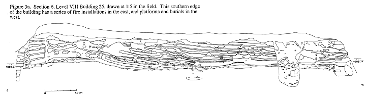
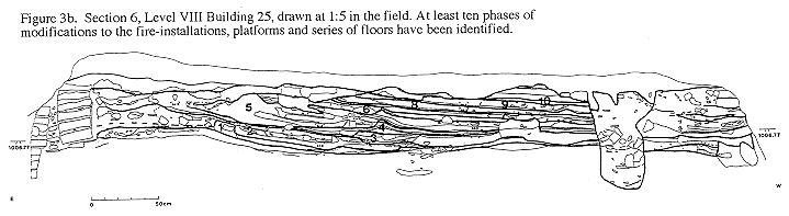
During cleaning we exposed a narrow strip of floors inside Shrine VIII.25. which had been left by Mellaart along the entire length of the southern wall as he excavated down into Levels IX-XII in 1965. This strip was only 36cm wide at its base and even narrower at the top where it was eroded, exposing white plaster on the southern wall face. The width of this strip is visible in cross-section in Section 8 (Figure 7). Despite some erosion this occupation sequence is unusually deep, at 43 cm, and includes a series of hearths, platforms and floors. These were drawn at 1:5 (Figure 3a), as well as at 1:20. At least 10 major phases of remodelling have been identified (Figure 3b), discussed below in part 4.3. The section face and internal structure was very cracked due to erosion and exposure over the last thirty years. Samples were difficult to extract but were successfully taken.
Level VIII.25 was interpreted as a shrine by Mellaart, perhaps because it had wall paintings, of nets, and two red ochre burials below the main eastern platform (Mellaart 1966. 167. Plate XLIVA) . The skull of an adult and several juvenile bones had been exposed by erosion in the unexcavated south western corner of this building, and were drawn at 1:5. The adult burial occurs late in the occupation of this building and cuts through all extant phases of floors and platforms. The juvenile bones were largely retrieved from loose eroded soil in small hollows in the cracked section face. The bones were examined by Dr L. Martin and include juvenile phalanx 1-3, ?pelvis, proximal articulation head of a humerus/femur, and vertebrae fragments. Some of the remaining bones were stratified below layers of plaster in phases 6-7.
3.1.2. Western section, East facing (Figure 2)
According to Mellaart Level VIII Building 27, next to VIII.25, was squeezed in at the junction of an upper (eastern) and lower (western) terrace (Mellaart 1966, 180). The features in the western section therefore, could potentially relate either to the upper terrace to the east or to the lower terrace to the west as identified by Mellaart. The task in studying these sections was to try and detect any stratigraphic evidence for a terrace at this juncture.
There are three apparently secure correlations of features in the western section with Mellaart's levels:
- The wall at the base of the section is the western wall of XII.25.
- The overlying ashy deposits correlate with Level XI "courtyard" or unroofed area.
- At the top of the section the protruding wall is the north eastern corner of VII. 10 on the basis of evidence in Section 8, discussed below.
There are, however, two alternative correlations of the intervening layers with Mellaart's Levels. The stratigraphic evidence available is incomplete because the surviving sections are at the junction of the off set corners of several buildings and open areas.
The first reconstruction is based on the relative sequences in the western and the southern sections.
- The building which cuts into the Level XI unroofed area in the western section, hereafter Building 2, may be contemporary with the Level X building in the southern section, hereafter Building 1. The base of Building 2 walls is 0.56m lower than those of Building 1 perhaps suggesting that if there was a lower terrace in Level X it was not very much lower.
- If Building 2 is contemporary with the lowest building in Section 8, see point 2 below, the lowest building level in Section 8, may be Level X. 1 0, and not VIII. I 0 suggested by the published observations in Mellaart (Mellaart 1966, 178). If this Building 10 were redated there would have been and step of ca. 0.8m from the base of Level X Building 1 walls, at 1005.86 to the base of the trench which is close to floor level in Building 10, at 1005.03.
- The ashy infill of Building 2 may be contemporary with the infill of Building 1, and may therefore correlate with Level IX.
- The overlying layers of ash probably correlate with the lower layers of Mellaart's Level VIII 'courtyard', which were the earliest deposits exposed in this vicinity during excavations in 1965.
- Level VII building 10 appears to be cut into Level VIII deposits.
The second alternative correlation and reconstruction is proposed on the basis of Mellaart's identification of levels for Building 10 which was excavated in the adjacent trench to the west, and studied in Section 8 (Figure 7).
- Mellaart states that he did not excavate below Level VIII in building 10. In Section 8 there are only two extant building levels. The lowest of these on the basis of Mellaart's statement is therefore Level VIII. 10, and the upper Level VII. 10.
- The smooth outer face of what is probably the southern wall for Section 6 Building 2 was uncovered in a small cutting in Section 8, behind packing between it and the building identified as Level VIII.10. The bricks and mortar of Building 2 and the wall in this cutting are very similar. The top of the wall in the cutting is at 1005.82 a.s.l., just above the top of the floors of Building 2 which are at 1005.78 a.s.1. Building 2 in Section 6, therefore, may be contemporary with the building identified as Level VIII. 10.
- The floor of VIII. 10 probably lies not far below 1005.03 a.s.l., which is the level of the base of the trench. The floors of VIII.25 on Mellaart's upper terrace are at 1006.63 a.s.l., at least 1.6m above those on his lower terrace in VIII. 10, suggesting that if there was a terrace from west to east in VIII it was in the order of 1.6m.
- There may also have been a step down from Building 2 to VIII. 10, for the top of floors in Building 2 are 0.75m higher than the base of the trench.
- If Building 2 is therefore correlated with Level VIII, the overlying ashy layers should all be correlated with Level VII, yet Mellaart states that he excavated down to Level VIII 'courtyard'.
The evidence currently available in these sections cannot refute one or other of these alternative reconstructions.
There has been some subsidence of the Level X Building 1 wall. This wall would have formed the facade of any upper terrace, facing west down slope. The subsidence is likely to have occurred either when the Building 2 foundation trench was dug, or during settling of the fill in this trench. Level X Building 1 walls were cut down to a height of 0.75m before the construction of Level VIII.25. The weight of these cut down walls is unlikely to have caused the subsidence, suggesting that the subsidence occurred before construction of Level VIII.25.
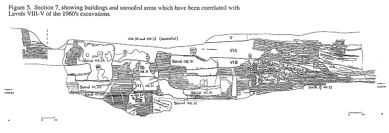
3.2. Section 7
It has been possible to correlate much of Section 7 (Figure 5 and Figure 6) with Levels and buildings identified by Mellaart, by analysis of his plans and the photograph taken in 1965 (Mellaart 1966, Plate XXXIa). The banks of collapsed debris at the base of Section 7 lie on top of Level Xll floors, and are estimated to be 2.25 metres thick, on the basis of comparison with the absolute height of Level XII floors in Section 6. The depression in the top of the northern half of Section 7 is where Mellaart excavated VIA.30 and 33. The photograph taken in 1965 was divided into vertical quadrants and compared to a drawing of Section 7 which had the estimated base of Level Xll floors dotted in, and was also divided into vertical quadrants. In both the photograph and the section drawing which had been correlated with Mellaart's levels on the basis of architectural analyses, the base of Level VIII lies just above the first quadrant, the base of Level VII lies at the halfway mark, and the base of Level VIB lies Just below the third quadrant line. It is with some certainty therefore, that the following correlations are proposed.
Section 7 (Figure 5) principally records a north-south cross section through three linear arrangements of buildings which are on a slightly radiating east-west alignment. The easternmost buildings excavated by Mellaart in each of these lines are Buildings 29, 31 and 32 respectively. Mellaart was not able to excavate the southeastern corner of Building 29 nor the north eastern corner of Building 31 in Levels VIII-VIB because they extended obliquely into the section face.
Level VIII
Level VIII is the earliest level now visible above the banks of collapsed debris in Section 7. The double wall separates building VIII.29 to the north from the building behind VIII.31 to the south. Mellaart was able to expose all of the eastern wall face of Building 31 in this level. It is presumed that this wall, and perhaps a western wall of the building behind, have fallen away to expose steeply sloping room fill in the unexcavated building behind VIII.3 1, that is to say in a building to the east.
There are two phases of walls and floors in VIII.29. The lowest exposure of Level VIII in this section is at 1006.69m a.s.l., which is probably close to the floor level given that the walls stand to a height of >1.62m. The base of the floors in Level VIII.25 in Section 6 is at very similar height, at 1006.63m a.s.1.
Level VII
There was a major phase of rebuilding across this area of the site in Level VII. The excavated plans show that Buildings VII. 29 and 31 shared party walls. The walls of both of these buildings have partly eroded from the section face to reveal that the buildings behind also shared party walls with VII.29 and 3 1. Mellaart had presumed from the position of the platforms in Building 31 that there must have been an open space to the east in Levels VIIIVI (Mellaart 1966, 181). The exposure of buildings east of Building 31 by erosion shows that this is not the case in Levels VII and VIB. The easternmost strip of floors in the antechamber in VII.31 are still visible in the section. The building behind VII.31 was modified before the building to the south behind VII.32 was burnt and infilled. The southern wall was cut down and rebuilt, and the floor surface raised 1.4m. This phase of modification in the building behind VII.31 is not present in any other building in Level VII in Section 7.
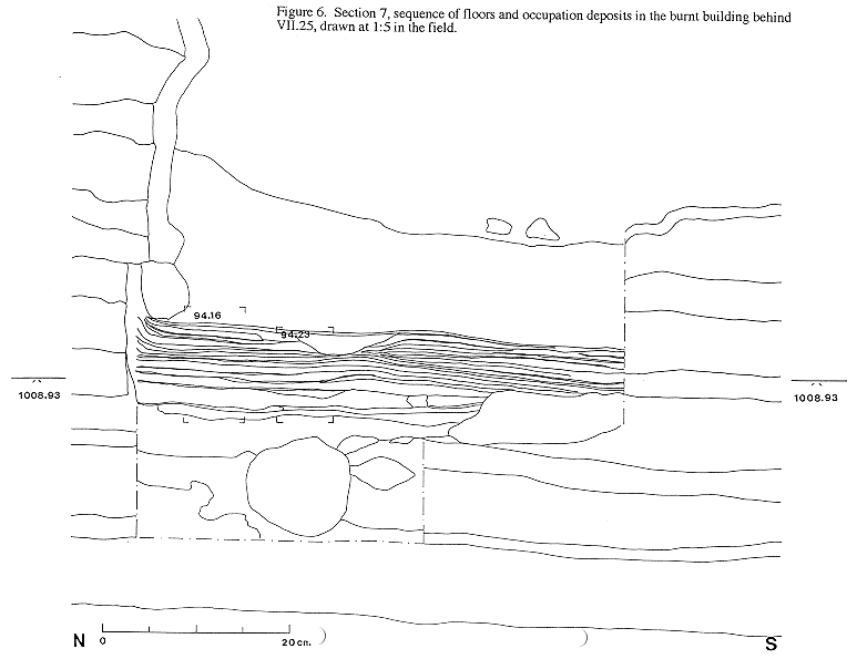
A large building has been exposed by erosion behind VII.32. It is more than nine metres in length from north to south. The outer wall of this building has partly eroded to expose the well plastered floors and the room fill which comprises steeply sloping layers of burnt and unburnt building materials. The southern half of the building had been burnt, and is discussed in part 4.4. The floors were drawn at 1:5 (Figure 6) and sampled.
Level VIB
Mellaart stated that
-
"upon partial removal of these houses 1 the stratigraphy showed that Shrines E.VIB.45, E.VIB.31 and House E.VIB.29 did not belong to Level VIB, but to Level VII"
(Mellaart 1966,166)
It is presumed that the houses referred to by foot note 1 are VIB.24-27, for they are the only buildings on his upper terrace which separate the row of Shrines 29-31 from the main excavated area (Mellaart 1964, Fig. 2).
The continuity in the use of buildings which had been constructed in Level VII is clearly visible in Section 7. In Level VIB the floor levels were raised 0.95-1.1m, and internal walls were constructed against the face of the party walls from Level VII in the building behind VIB.29, and in VIB.3 1. The building behind VIB.3 1, by contrast, was completely rebuilt on top of cut down walls from Level VII. A thin burnt lens from the destruction of the large burnt building in VII overlies these cut down walls, and suggests the burnt destruction of the building took place after the ground in the adjacent plot had been cleared. The unburnt bricks in the room fill of the level VII burnt building behind VII.32 are the same distinctive large size, colour and clayey sand texture as those used to construct the building on the cleared plot behind VIB.3 1.
Mellaart stated that although Shrine VIB.31 was one of the best preserved standing to a height of 6 feet, its north and the greater part of its eastern wall had been destroyed right down to the lower red dado on the platform (Mellaart 1964, 45). The building to the east of VIB.3 1, now exposed by erosion, had also been severely truncated in antiquity and is cut by pits and overlain by ashy deposits which are characteristic of some sectors of this area of the site in VIA. The western and southern walls of VIB.31 had plastered reliefs of bulls heads and goddesses (Mellaart 1964, 45-47, Fig.7), the remaining segment of the east wall had a plastered relief of a figure with hair flowing out behind it (Mellaart 1964,47).
The southern sector of Section 7 was an unroofed area in VIB. Layers of ashy midden accumulated on top of the burnt building, perhaps in a large pit.
Level VIA
Mellaart excavated Buildings VIA.30 and 33 in the area immediately to the east of the section face, where there is now a hollow in the top of the section. His plans of Level Vla indicate that these buildings are surrounded by ashy deposits. Level VIA in fact, as Mellaart stated, is characterised by less tightly packed buildings and more unroofed areas (Mellaart 1964,39-40). His photograph of the northern sector of Section 7 shows some disturbance at the top on the southern edge which corresponds to the disturbed ashy deposits surrounding wall fragments in the northern and central area of Section 7 (Mellaart 1966, Plate XXX1a). This disturbance is just discernible on the general view of the site which includes the main eastern section (Mellaart 1966, Plate XIX).
The surviving strip of floors in the north eastern corner of a building are almost certainly those of VIA.32. The outer face of a building to the east has been exposed by erosion. The internal SW corner of this building has also been eroded, exposing the lines of the interior white wall plaster. These buildings are surrounded by ashy deposits, like Buildings VIA.30 and 31.
Level V
The latest surviving level now visible in Section 7 is Level V in the south of the section. The floors and walls of the building behind V.7 and the lane between this building and F. V. 1 have been cut by the section. Excavations in F.V.1 uncovered spectacular wall paintings with hunting scenes (Mellaart 1966, 184-194). This building is not present in the section further to the south, because the lane which continues to the east and south was traced by excavation. Mellaart excavated below Level V in Area F to Levels VIA and VIB, including Shrine 80 which lies below F.V.1. There are no published plans of these buildings in this southernmost quarter. The only indicators of the settlement layout and the location of each building are tentative three dimensional reconstructions (Mellaart 1966, Figures 5 and 6).
3.3. Section 8 (Figure 7)
The eroded outline of Building 10 could be clearly traced on the ground and corresponded to the measurements on Mellaart's plan. Mellaart states that he did not excavate below Level VIII in Building 10 (Mellaart 1966,178). In Section 8 there are only two extant building levels. The lowest of these on the basis of Mellaart's statement is therefore Level VIII. 10, and the uppermost is Level VII. 10. According to Mellaart, Level VIII. 10 was rather plain with little decoration, unlike the later buildings. Building 10 in Levels VIB-VIA in particular was one of the best preserved and most complex buildings at Çatalhöyük and is reconstructed in the Ankara Museum of Anatolian Civilization, where it has stacked bulls heads and goddesses (Mellaart 1966, Fig. 9, for Level VII see Fig. 17).
Loose debris was cleaned away from the section face. Fragments of white wall plaster adhered to the inner face of the lowest building level, correlated with level VIII.10. at the base of the section and curved in towards the room in the north western corner suggesting we were close to the original floor level. Most of the walls from the uppermost building, correlated with VI 1. I 0, had fallen away from the section face and lay face down in the base of the trench. These were not lifted to expose the floor in case any wall plaster or features still adhered to the face of the fallen blocks.
The south-western corner of Building VIII.25, Section 6, is exposed in the west facing section here. The floors are just visible through the eroded vestiges of the western wall edge of VIII.25. Level IX "courtyard" or unroofed area is only a thin strip of ash in this section. Building VIII.25 is almost built directly on top of the wall which is probably from Level X, Section 6, and is also visible behind the eroded face of VII.10. The extant face of the wall from probably Level X, is irregular and had been cut by the building identified as VII. 10. Irregular depressions in the extant surface of the probable Level X wall, behind the mortar/packing from VII. 10 might perhaps be vestiges of Neolithic pick marks.
3.4. Section 9 (Figure 8)
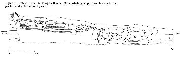
During cleaning of the southern sector of Section 7, we uncovered the edge of an unexcavated building to the south of Level VII.32. The edge of this building was traced west from the face of Section 7 for a distance of 3.24m, where it petered out due to surface erosion. The northernmost wall of this building was completely eroded away. The only suggestions of its original location were remnants of white wall plaster curving out west from the face of Section 7. The building had been severely truncated by erosion. The debris on top of the surviving platform and floors was only 22-28cm thick. This debris principally comprised multiple layers of collapsed white wall plaster which had traces of red paint in the section face on some of the layers. This building had been burnt, as had the well preserved building behind VII.32, in Section 7 to the East. The platform and floors were heavily burnt and rubified, dark reddish brown. Burnt vegetal stabilisers in the platform structure and the plaster floors were visible with the naked eye.
4. Site structure
The recorded field sections from the 1994 season enable examination of a total depth of 8.55 metres of occupational sequences through the mound from 1.35m to 9.9m above the level of the plain, 7.6 metres below the summit which is at 1020.5m a.s.1. The sections from last year join up with those from this year at the southern edge of Section 3 and northern edge of Section 7. The highest levels recorded last year are 1015.42m a.s.l., 4.88m below the summit. The conjoinable sections enable study of 11.07 metres of occupational sequences from Level XII-Ill. This total height represents 65% of the height of the mound above plain level, or ca. 53% of the total height of the mound, including deposits buried below the plain which have been detected by geomorphological augering and in Mellaart's' sounding in 1963 (Roberts 1993 and 1994; Mellaart 1964,73).
4.1.Architecture
Mud bricks
The mud bricks studied this year from Levels XII-VIII are greyish brown in colour and are made from sediments exposed to reducing rather than oxidising conditions. The studies of mud brick in the field and in thin section are being compared to analyses of sediments in the surrounding region conducted by the geomorphological team.
The mud bricks increase in thickness through time. There is a marked increase in brick size from Level VIB.
Mortar
The mortar in Levels XII-VII originated from at least three sources of sediment: greyish brown sediments exposed to reducing conditions; dark grey anthropogenic debris and, more rarely, white carbonate rich sediments.
Wallplaster
It was difficult to count the number of wall plaster layers in the sections due to smearing and blurring by erosion. Building VIII.25 and the burnt building in the southern half of Section 7 have at least 40 layers of plaster on exposed wall faces.
Double wall construction
All of the walls at Çatalhöyük are constructed from single widths of mud bricks each up to one metre or more in length. The load bearing outer walls of buildings are often separated from walls of adjacent buildings by a thin layer of constructional packing, 2-10cm thick.
In Level VII at the southern end of Section 7, the distance between the walls is slightly larger than usual, the buildings behind VII.31 and VII.32 are up to 20cm apart. The upper layers between these walls may have been infilled over a period of time by accumulations of ashy refuse and deposits which may be wind and water laid. Building VIB-VIA.32, excavated by Mellaart immediately to the west of this same sector of Section 7, was also separated from the surrounding buildings, by distances in the order of 60cm.
There were no double walls between Buildings 29 and 31 in Level VII which were excavated and planned by Mellaart. These two buildings are unusual for they share the same party walls (Mellaart 1967, Fig. 10). The buildings to the cast which have been exposed by erosion also share party walls with Buildings 29 and 3 1. The walls consist of single bricks which are plastered on both sides, facing west into Building 31 and east into the unexcavated building behind.
Because these buildings have not been excavated it cannot be ascertained whether the occupants or activities within these four buildings were related in any way, as the sharing of party walls might suggest. Mellaart observed that:
"On the upper terrace itself, the close association of rooms 29 and 31 apparent in Levels VI and VII is still more pronounced in Level VIII (Fig. 7), where room VIII.29 seems to have served as a meeting-room and is provided with a long bench set against the north wall and several ovens."
(Mellaart 1966,180).
The change in the boundaries between these buildings from Level VIII to Level VII, therefore, may either be indicative of a complete break with the past, or of some form of cooperation or association between the occupants.
There were no double walls in Levels XII and XI, according to Mellaart, instead there were party walls occasionally supported by buttresses (Mellaart 1966, 168).
Modifications
Additional walls may be built inside existing walls to reinforce or repair walls which were tilting, burnt, or had thick layers of wall plaster, as in the case of buildings VIB.31 and behind VIB.29, Section 7. Mellaart estimated that Shrine VII-VIB.31 lasted for over a century, and had not less than four layers of burials below it (Mellaart 1966,166).
4.2. Phasing and terracing
Analysis of the structure of the site, of the spatial and temporal relationships between buildings, and between buildings and unroofed areas, is fundamental to the study of the social, economic, ritual and artistic relationships across the site and to the study of any changes or developments through time.
Mellaart identified twelve major building levels during his excavations. His reconstructions of these levels and a schematic section through the mound illustrate buildings terraced down the western slope of the mound (Mellaart 1964, Fig. 3 and 1966, Figs. 5-6). The top of Level V in the east of Area E for example was five metres higher than the buildings on the lower western part of the slope. Mellaart changed his identifications of different building levels during excavation (e.g.. Mellaart 1964, 42; 1966, 166). These changes were due in part to the continued use of some buildings whilst others were levelled and completely rebuilt. Mellaart identified his Levels on the basis of area exposure, brick sizes, materials and colours (Mellaart 1966, 176).
The complexity of the site structure and phasing is clearly evident in Section 7, in particular.
In this recent study of the sections, separate phases or levels have been identified where a change in the mud bricks or walls can be associated with a new floor level. Only one completely horizontal phase of levelling was identifiable, from Level VIII-VII, along the contours of the mound. This levelling can only be traced across the space of two buildings, due to the more limited exposure at the base of the section. This levelling does, however, suggest some form of Co-operation between the new builders. Indeed, the overlying buildings all share party walls, namely buildings VII.29 and 3 1, and the two buildings exposed by erosion to the east. There is a change in the plan of the antechamber in VII.31 which is extended north to take up space originally used by VIII.29.
Although the final levelling of Level VIII buildings was uniform, there had previously been some organic development within the structures of the separate buildings. Building 29 was rebuilt with different mud bricks and the floor level raised at least 0.94m, whilst the adjacent building, behind 31, retained its original walls and probably floor levels. This would have presumably resulted in a step of almost one metre between the roof tops of both buildings.
A similar difference in the organic development of adjacent buildings is attested in Level VII. The building behind VII.31 was apparently rebuilt and the floors raised 1.4m, whilst the adjacent building behind VII.32 continued in use, unmodified. This modification is similar to the raising of floors and insertion of walls in Level VIB.29 and 3 1. Although the insertion of walls into the building behind VIB.29 and building VIB.31 is at the same absolute level and would appear to be contemporaneous, the relationship of these modifications to those in the building behind VII.31 which was completely rebuilt is not evident from the surviving section. If our correlations with Mellaart's levels are correct, the division suggested by the terms VII and VIB is misleading for there is more continuity in this section between VII and VIB than there is between VIB and VIA, as Mellaart himself stated (Mellaart 1964,42). There are a number of major changes in the structure of the site in VIA. In conclusion to this particular point, there appears to be considerable organic development within individual buildings from Level VII-VIB, with up to three phases of modification evident in some buildings.
The stratigraphic evidence for major terracing westwards down the slope of the mound can only be sought in Sections 6 and 8 and is discussed in part 3. 1, Section 7 only runs along the contours of the mound. Sections 6 and 8 are situated at the juncture of the upper and lower terrace in Area E referred to above. In summary, there was irrefutable evidence that the wall identified as belonging to VII. 10 had been cut into the western wall of a building almost certainly attributable to level X in the sequence identified by Mellaart. The difference between the base of VII. 1 0 and the eroded top of VIII.25 is 1. 17m, suggesting there may have been a terraced step between the buildings at least one metre high. However, because we are only working with the surviving sections at the base of Mellaart's excavations we cannot asses the stratigraphic evidence for terracing in higher levels and cannot examine the relationship between Mellaart's VII.25 and VII. 10. We do not have a secure starting point from which to examine the relative sequence between these two sections. It should also be borne in mind that given the organic development of adjacent houses, there would probably have been steps of a metre or more between buildings at irregular intervals.
The sections studied during the last two years will be analysed further and matrices of the site structure constructed.
4.3. Nature of floors and occupation sequences.
It is too premature to discuss the nature of floors and occupation deposits examined in the field sections, until the thin sections from all of these sequences have been analysed. Thin section analysis, interpretation, and preliminary observations are discussed in part 2. 1. Once thin section analyses have been correlated with observations and descriptions in the field, it should be possible to ascertain the character and origin of deposits from examinations in the field with greater certainty.
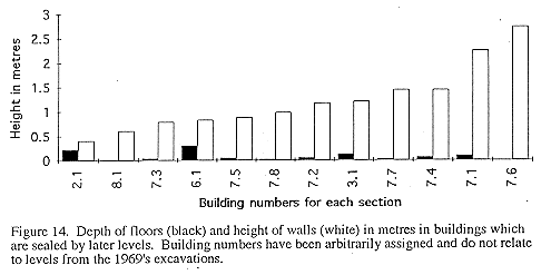
The total depth of floors and occupation sequences in the buildings studied vary from 230cm, the sequence in VIII.25 is exceptionally thick, despite erosion it is still 43cm thick. In sealed buildings floors and occupation deposits only represent 2-55% of the height of the preserved walls, which stand to a height of 0.42-2.73m.
The total thickness of a single layer of occupation debris between plaster floors is not greater than 2cm, with the exception of layers at the end of each phase in VIII.25. Here each new phase is represented by a levelling of the current fire installation and distribution of the debris across the floors in layers up to 3-4.75cm deep (Figure 3). New platforms are often built in the south western corner of this room in order to compensate for the rise in floor level. Until the deposits are analysed in thin section only a preliminary estimate can be made of the number of floors for each of the ten phases identified. The layers of white plaster are very thin, a single layer observed in the field may prove in thin section to comprise several applications of plaster. Other layers are greyish brown in colour. In the field it is not yet possible to determine whether these are layers of trampled occupation debris, or layers of deliberately laid plaster prepared from greyish brown sediments. According to a preliminary assessment in the field, the number of layers of plaster or plaster/trample varies from 1- 16 per phase. There is an estimated total of 50 layers in the surviving sequence.
4.4. Infilling
Four major types of infilled deposits have been identified in the sections:
1. Burnt structural debris.
The only examples of burnt infill surviving in the sections occur in Section 7, in the northern antechamber of Building VIB.31 and the building behind VII.32, and in Section 9 in the building south of VII.32. Only a small disturbed section through the northern antechamber of Building VIB.31 survives, which includes collapsed baked mud bricks in charred debris. This burning may have been localised because Mellaart states that the main room was not burnt. Less than 30cm of collapsed burnt plaster and debris survive in the truncated building in Section 9. Mellaart states that:
"whereas the crowded settlement of Levels VII and VIB were not-or only partly -destroyed by fire, all subsequent building-levels perished in conflagrations"
(Mellaart 1966, 172)
The infill of the burnt building behind VII.32 slopes steeply down from the north. This fill includes baked mud bricks and mud brick fragments, orange and dark pink in colour, which constitute 20-80% of the deposits in layers within the fill, large beams of juniper wood more than 20cm in diameter, collapsed wall plaster burnt pale blue, unburnt wall plaster, and unburnt mud bricks, which constitute 0-50% of the layers of infill. These components tend to occur in layers 10-50cm thick which are interbedded throughout the fill. The burning in this exposed section of the building was confined to the southern half of the building where it has baked the plaster on the walls and rubified the outer face of the mud bricks behind. This localisation is surprising, given the intensity of the burning which had baked more than half of the bricks in the fill, and had burnt the wall plaster on the western wall blue in colour. Similar areas of localised burning within buildings have been observed during surface studies at the north of the mound. Ruth Tringham has suggested that burnt buildings in south eastern Europe may have been ritually burnt at the end of their use (Hodder pers comm.). The localised, perhaps controlled, extent of the burning discussed here, may support the hypothesis that some buildings at Çatalhöyük were ritually burnt at the end of their use. This hypothesis may be further supported by the fact that the infill of the burnt building behind VII.32 includes unburnt mud bricks which are identical in size, colour and texture to those used in the construction of the adjacent new building in Level VIB, and does not include the old debris from the adjacent walls of the building behind VII.31 which must have stood higher, and could have easily been pushed into the cavity in this burnt or burning building. On the contrary, the lens of charred debris which overlies the wall stub of the building behind VII.31 suggests this building was levelled before the building behind VII.32 was burnt. The burnt building, moreover was not infilled as part of a levelling operation onto which later buildings were constructed. The area was subsequently used for deposition of refuse. It is not clear from the stratigraphic evidence in the section whether the southern part of this building was only partially infilled, and later covered by refuse, or whether it was cut by a large refuse pit. In this particular instance at Çatalhöyük, therefore, the localised perhaps controlled extent of the burning, and the use of new mud bricks to infill the building may support the hypothesis of a ritual ceremony to mark the end of activities in this building.
Similar suggestions of ritual practices associated with the cessation of use of buildings were made by Mellaart:
With regard to AIII.8 "after its destruction by fire the entire building was remodelled with panelled walls, thickly coated with white plaster and then filled in with a clean fill of decayed mud brick containing not a single object. After the fire it had evidently not been used and the care taken over its remodelling previous to its filling in suggests again that we are not dealing here with a private house, but a shrine. No burials were found below its floor. It is now clear that exactly the same procedure was followed after destruction (by fire) of ..AIII.1, EIV.1, EVI.8 and EVI.7... In the case of the remaining shrines (EVI.10, 14, 31, and AVI.1) the rooms were already partly filled with masses of burnt brick of walls fallen and fused with in the fire which made clearance with stone tools impracticable. Under those circumstances more debris from other buildings was added and no attempt was made to clear and plaster them, so they were found intact with their contents. The others had been more or less cleaned out."
(Mellaart 1963,47-48)
2. Deposits with mud brick and plaster relief fragments.
Only two buildings in the sections have sizeable fragments and quantities of mud brick and plaster relief fragments, namely the southern building in Section 3, and the eastern building at the top of Section 1.
3. Homogeneous, well sorted mineral sediments and flecks of white ?plaster.
Many of the buildings in the sections have a homogeneous well sorted infill of mineral sediments with flecks of white ?plaster of currently unknown origin, which was almost certainly deposited within the buildings as a single event. This infill does not include pushed in walls or collapsed mud bricks. In some cases this is because the walls were left standing to considerable heights, and rapidly infilled when the building was no longer in use. In other instances however, the whereabouts of mud brick from walls which have been cut down to a height of approximately one metre, is currently unknown.
During excavation of some buildings, such as E.VIB.31 Mellaart observed that:
"The large head, arms and feet are broken and as the building was not destroyed by fire it would seem that this destruction was a deliberate act, a sort of desecration before it was abandoned and filled in."
(Mellaart 1964,47)
In other instances in buildings in level VIB and VII which had not been destroyed by fire but which had been abandoned after very long occupation artefacts, beams and animal heads had often been removed, and were pulled down and filled in (Mellaart 1964, 39 and 50)
4. Deposits rich in plant remains and bone.
Refuse deposits in buildings occur either as i) homogeneous layers up to 0.8m thick which accumulated over a short period of time, perhaps imported as levelling fill, or as ii) thin more heterogeneous layers which probably accumulated over a longer period of time originating from periodic cleaning within buildings, hearths and ovens, and from roof tops. The build up of heterogeneous deposits in Level XI within the walls of XII.25 appears to have occurred after some collapse of the wall plaster onto the floors. Mellaart had observed that many condemned buildings were used for rubbish disposal and sanitation. This practice however, was not always restricted to infilling upstanding walls, but on occasions was extended to cutting down walls and buildings in order to create large pits, as in Level IX Section 6.
The infill of buildings at Çatalhöyük was a complex practice, and should be studied in conjunction with analysis of the use of the buildings, the extant height of walls, and duration of phases, for example.
4.4. Vertical structure of the site
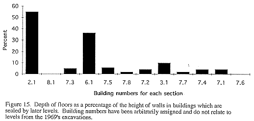
In sealed buildings, the total depth of floors ranges between 2-30cm and represents only 255% of the height of the walls which range between 0.4-2.73m (Figure 14 and Figure 15).
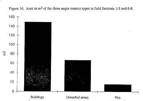
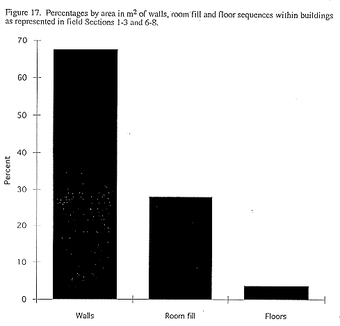
The area occupied by the major context types in the field sections has been traced and calculated for the main north-south and east-west sections, Sections 1-3 and 6-8 (Figure 16 and Figure 17). Buildings occupy 149.34m2, 64.4% of the total 231.98m2 area in these sections, unroofed areas 66.8m2 or 28.8% and pits, many of them classical, 15.84m2 or 6.8%. Within buildings, walls constitute the largest areal component preserved in the sections at 100.8m2, or 67.5%, room fills 41.79m2, or 28%, and floors only 5.51m2 or 3.7%.
| |
© Çatalhöyük Research Project and individual authors, 1994