ÇATALHÖYÜK 1994 ARCHIVE REPORT
| |
Çatalhöyük 1994
Roger Matthews and Ian Hodder
Introduction
A second season of renewed fieldwork at the site of Çatalhöyük on the Konya plain took place between the 22nd of August and the 30th of September 1994. As with last season the aim in 1994 was to obtain as much information as possible concerning surface aspects of the site, prior to the commencement of excavations in 1995. To this end, a full range of techniques was employed, including topographic survey, local fieldwalking, surface collection, subsurface scraping and planning, magnetometer survey, section cleaning and sampling, and a range of geomorphological investigations. These procedures yielded results which are of value in their own right, but which will also assist in deciding which parts of the mound to excavate in future seasons.
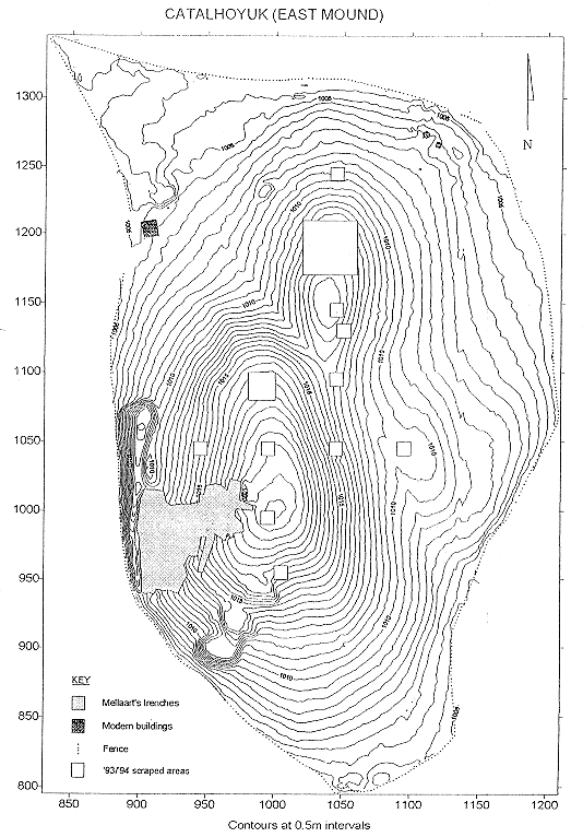
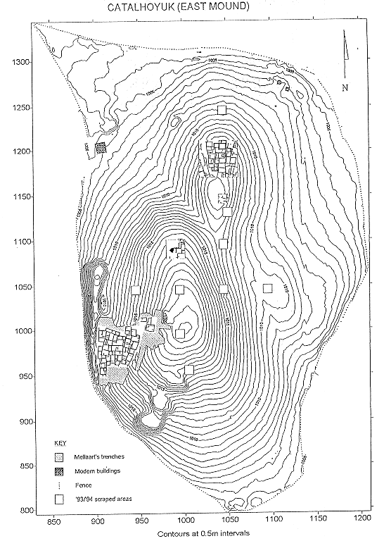
A topographic survey and grid layout of the east mound was completed this season (Fig 1). The entire area of the mound contained within the modern fence was surveyed and contours plotted at 0.25 m intervals, clearly showing the three eminences, the largest of which was excavated on its western slopes in the 1960s. Large spoil heaps from these excavations cover much of this region of the mound. The total area of the east mound, as bounded by the fence, is now established as 13.5 hectares. A site grid at 20 m intervals was laid out across the west mound, which will be fully contour surveyed next year. The west mound covers 8.5 hectares. Contour survey of the region between the two mounds will also be undertaken in the future.
During the course of the season advantage was taken of an extensive irrigation and drainage project across the landscape surrounding the site to carry out fieldwalking surveys, particularly to the north, east and south of the east mound. The results indicate that there is little in the way of prehistoric surface remains or artefacts in the immediate environs of the east mound, and that the modem fence does constitute a genuine definition of the visible limits of the site, although much may be buried below recent alluviation. The major find was of a large Byzantine site, covering at least 10 hectares, whose western limit lies only a few hundred metres to the east of the east mound. This site is not visible as a raised feature but as a consistent spread of pottery, bone and tiles. Its presence provides a settlement context for the numbers of Byzantine burials which we have encountered during current work at Çatalhöyük. Evidence was also found of an ancient channel of the Çarsamba river which at some time passed between the east and west mounds.
The programme of surface collection was completed this year. Artefacts were collected from 2 by 2 m squares at 20 m intervals across both the east and west mounds, using sieves of 5 mm mesh. General results of this programme on the east mound were presented in our report on the 1993 season. This year we present detailed reports on specific artefact categories: pottery, bone and lithics.
Subsurface scraping
The programme of subsurface scraping, commenced in 1993, was continued this season, with a further twenty-one 10 by 10 m squares being cleared and planned. Eighteen of these squares were located on the east mound, and three on the west mound. The location of squares scraped on the east mound in 1993 and 1994 is shown in Fig 1. As with last season, mixed results were obtained from subsurface scraping. In some cases very few features could be detected, while elsewhere extremely detailed plans were recovered. The following account of the 1994 scraping programme begins at the southern end of the east mound. In all cases, grid co-ordinates refer to the south-western corner of each square.
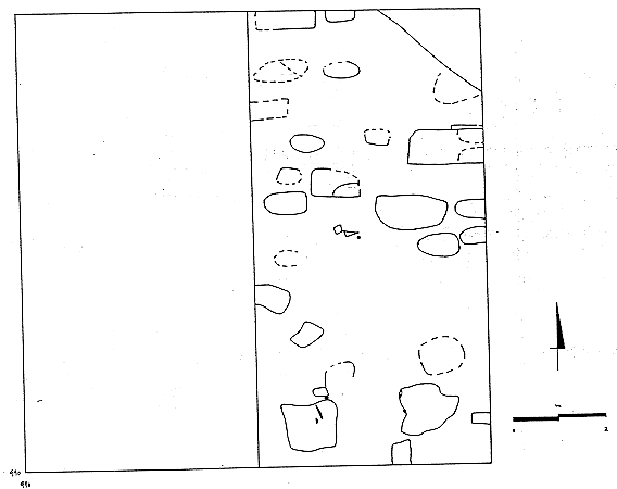
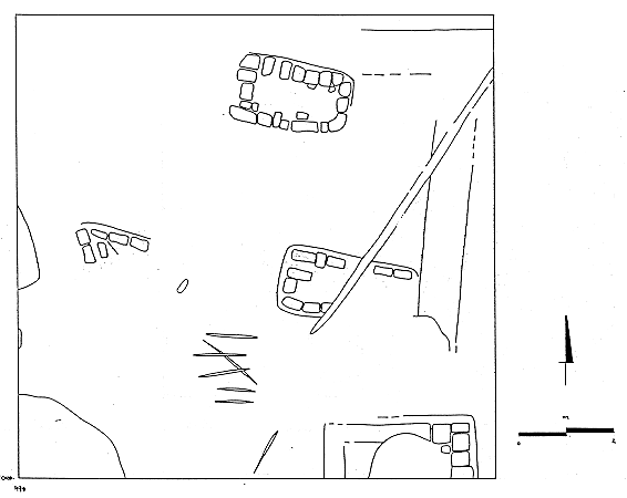
Two squares near the summit and southern slopes of the main eminence of the east mound yielded little in the way of prehistoric results. In square 1000, 950 no architectural features at all were detected after the removal of up to 20 cm of surface soil. Some alignments of stones and faint traces of pits may indicate the presence of Byzantine graves. Pottery recovered from this square supports our previous interpretation, based on collection of surface artefacts, that the entire southern reaches of the east mound are extensively overlain and disturbed by Classical and Byzantine deposits. In square 990, 990, immediately to the south-west of the mound's summit, again no architecture was detected. A series of non-overlapping pits, almost certainly Byzantine graves with an east-west alignment, was cleared and planned in the eastern half of the square (Fig 2). Some of these pits were lined with mud bricks. The small size of many of the pits suggests a high incidence of child burial here.
Scraping in square 990, 1090 in 1993 had revealed a reasonably coherent plan of Neolithic rooms, which was further traced this year by the clearance of three 10 by 10 m squares from point 980, 1080, making a total plan of 20 by 20 m in this area (Fig 3). Neolithic walls, built of large mud bricks and with little evidence of wall plaster, continued into square 990, 1080, but were sparse in the western half of the cleared area. Large spreads of burnt debris, probably largely Neolithic in date, have obscured much of the surface architecture. An unusual feature is the series of six parallel walls spanning squares 980, 1080 and 980, 1090. These are all Neolithic in date, as attested by their brick sizes and their attachment to the series of Neolithic rooms to the east. The finding of a fine clay stamp seal fragment in square 990, 1080 further supports a Neolithic date for these structures. The extensive spread of burnt rubbish in the south-eastern part of square 990, 1080 correlates well with a large area of burning detected in magnetometer survey.
Further to the north-east, magnetometer survey had revealed a series of rectilinear alignments suggestive of a large structure immediately under the mound's surface. Clearance of square 1045, 1125 showed that the entire square was covered by rubbish deposits (Fig 4), all Neolithic and yielding much in the way of pottery, animal bone and obsidian. It seems that the magnetometer had detected strips of rubbish burnt to varying degrees, rather than mud brick walls.
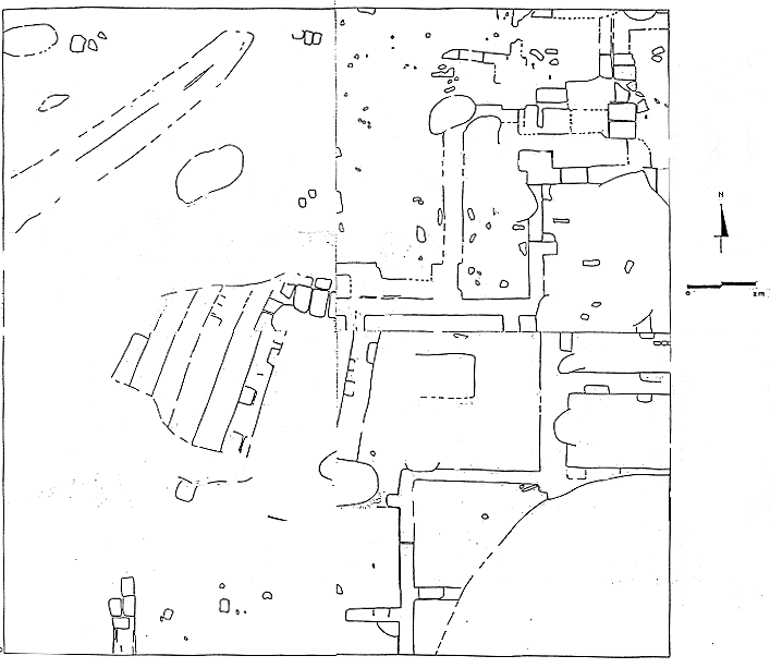
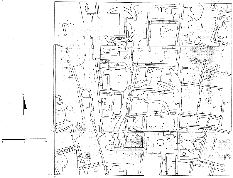
In 1993 we cleared and planned in detail a complex of Neolithic buildings in an area of 20 by 20 m from point 1030, 1180. Scraping in this northern region of the east mound was so productive that this year we expanded the cleared area into a 40 by 40 m square, with its south-western corner at 1020, 1170, entailing the clearance of an additional twelve 10 by 10 m squares surrounding last year's scraped area. By these means we have recovered a detailed and largely coherent plan of some thirty Neolithic structures over an area of 1,600 m2
The brick-by-brick plan of these structures is illustrated in Fig 5, showing relatively little in the way of later disturbance of the Neolithic deposits. One recent feature is the pair of circular arcs of ditch in the north-western quadrant of the cleared area, which also showed up well in the magnetometer survey. Examination of a 1960s photograph of Çatalhöyük, taken from the north-west, reveals that these ditches were almost certainly dug around a tent pitched on that part of the mound during Mellaart's excavations (Mellaart 1967, Pl 1).
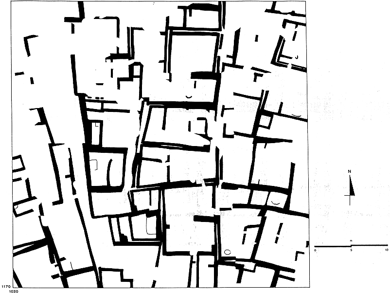
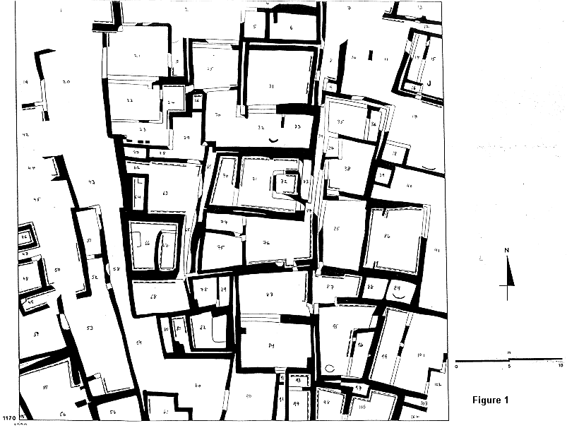
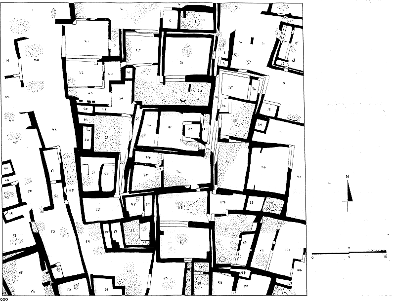
The spatial organisation of the Neolithic buildings is more readily comprehended in Fig 6, Fig 7 and Fig 8, where walls have been depicted in solid black. Fig 6 is an accurate representation of all walls found during subsurface scraping, while Fig 7 includes additional walls, indicated in outline only, which have been provisionally reconstructed in order to make sense of walls which, for a variety of post-construction reasons, are only partially visible. In Fig 7 dashed lines parallel to wall faces indicate the presence of white wall plaster on those faces, while areas of burning are indicated by stippling in Fig 8. Space numbers are also designated in Figs 7-8. The complex of Neolithic buildings planned by us in this part of the mound is of great significance and is now considered in more detail.
The general alignment of these buildings is of note, with a distinctive radial sweep to the alignment as we proceed from west to east. In the central strip of the cleared area walls are aligned approximately north-south and east-west, while to either side there is a marked swing in the major alignments. The cause of this radial effect is unknown, but may relate to the presence of streets or passageways into the centre of the settlement. One such street passes through the scraped area (Spaces 1, 20,43 and 58-60), forming a clear western boundary to a large complex of buildings. Continuity of walls and deposits across most of the scraped area suggests a strong degree of contemporaneity of these buildings, with the possible exception of Spaces 19,42 and 44-50, which may belong to an earlier level exposed by erosion of the western slopes of this part of the mound.
In general terms, and in many of the details, these structures bear close comparison to the Neolithic levels excavated on the south-western slopes of Çatalhöyük in the 1960s. All walls are constructed of unbaked mud brick, usually of large dimensions (up to and over 1 m in length), and there is an aversion to the use of party walls between buildings. This frequent use of double, occasionally triple, walls is also matched in the Aceramic Neolithic and Chalcolithic architecture of Can Hasan III and I (French 1962). There are almost no true right angles and the feeling is of an organic, cellular agglomeration of buildings over time rather than a unified planned layout. Frequent use is made of white wall plaster, generally with multiple applications visible in plan, as betokened by dashed lines in Fig 7. Lavishly plastered features or niches also occur, and there is every indication that many of these rooms have qualities typical of the so-called shrines of the 1960s levels, including a spectacular pair of its situ cattle horns in Space 89.
Buildings appear to consist of one large room, often approximately square in plan, with or without additional smaller rooms, but the lack of doorways between rooms renders difficult a precise division of all rooms into discrete house units. Brick and plaster platforms are detectable in some of the large rooms, such as Spaces 53, 63, 66, 71 and 82.
Room sizes also compare well to the 1960s buildings. A provisional analysis of the sizes of large rooms in the 1020, 1170 area and from successive levels of the 1960s excavations shows an overall compatibility, as presented in the following table.
| Level | Large room average area | Sample size |
| 1990s 1020, 1170 | 22.00 m2 | 17 |
| 1960s III | 17.93 m2 | 3 |
| 1960s IV | 24.26 m2 | 9 |
| 1960s V | 21.16 m2 | 6 |
| 1960s VI A | 19.22 m2 | 26 |
| 1960s VI B | 19.31 m2 | 30 |
| 1960s VII | 20.28 m2 | 17 |
| 1960s VIII | 24.40 m2 | 8 |
| 1960s III-VIII | 20.94 m2 | 99 |
Discrete areas of burning were detected across the scraped area, as indicated on Fig 8. In some cases entire or almost entire rooms, such as Spaces 38, 63, 82 and 89, are filled with heavily burnt material, while elsewhere more restricted patches of burning occur, sometimes in association with ovens or hearths, as in Spaces 17, 32 and 95. In some instances it may be feasible to associate burning with the deposition of rubbish in open areas, such as Spaces 30, 32-33 and 60, but in other cases we have to consider the possibility of destruction of particular rooms, perhaps deliberately, prior to rebuilding or abandonment. There is, in any case, no convincing evidence here for any extensive destruction by fire across the whole building complex, but rather the impression of strictly controlled use of fire within coherent and discrete architectural contexts. A comparison of burnt areas in the scraped area with the results of the magnetometer survey shows a high degree of correlation.
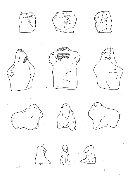
Artefacts from these buildings were very sparse, agreeing with the interpretation that the complex did not suffer from a mass destruction, by fire or otherwise, but was routinely and carefully cleaned prior to rebuilding. Pottery, bone and lithics were not found in great quantities. There was a steady representation of burnt clay balls, usually in fragments, probably used as pot boilers. A total of ten figurines, or fragments thereof, was found in the scraped area, including humans, animals and birds (Fig 9). The relative dearth of artefacts from this dense area of buildings can be contrasted with the very high frequencies of Neolithic artefacts found in other areas of the site where architecture is not visible but where rich burnt rubbish deposits occur, such as square 1045, 1125 or, from last season, square 1040, 1040. Although strict contemporaneity between houses and rubbish remains to be established, the impression is that the Neolithic residents of Çatalhöyük carefully and regularly cleaned their buildings, depositing their rubbish in discrete areas of the mound.
The existence of this practice has several implications. Firstly, it is clear that future excavation of these clean buildings will have to contend with a significant lack of in situ artefacts upon which to base interpretations of room function and social and economic issues, thus underlining the importance of a rigorous micromorphological programme for the recovery of minute traces of activities within rooms. Other areas of the site, however, may yield extensively destroyed Neolithic levels, such as Mellaart's level VI A (Mellaart 1964,40), in which many in situ artefacts may occur. Secondly, careful excavation of Neolithic rubbish dumps, again involving micromorphology, is certain to provide detailed and extensive information concerning the range and types of activities conducted within built-up areas, and to give some diachronic understanding, even at the seasonal level, of the rhythms of domestic and agricultural life at the site. Thirdly, the presence of large open areas of burnt rubbish within the Neolithic settlement has important implications for any attempt to understand the overall structure and layout of the site. Although these issues require much future work, a tentative first impression is that at any one time the settlement at Çatalhöyük did not consist solely of densely packed agglomerated buildings with every available part of the mound occupied, but that large open spaces existed between built-up areas. Parts of these open areas may have been encroached upon in times of high population density, but generally they were used for rubbish disposal, the rubbish always burnt in order to reduce smell and keep away dogs.
Perhaps most significantly, the presence of extensive open areas has important bearings on future demographic study of the site, pertaining to issues of population size and density. Fig 10 shows the plan of the east mound with the architectural results of surface scraping superimposed for areas 980, 1080, 1040, 1140; and 1020, 1170. Level VI B of the 1960s excavations is also included. Large-scale burnt rubbish deposits of probable Neolithic date occur in areas 1040, 1040; 1045, 1125; and parts of 980, 1080. This plan gives a preliminary idea of the scale of occupation on the east mound. Current attempts to address demographic issues at Çatalhöyük are likely to be greatly assisted by future work at the site, but some initial ideas can here be explored (for detailed coverage of these issues, as they relate to a Sumerian city, see Postgate 1994). Let us firstly assume that during a given time of the Neolithic period the east mound was in its entirety as densely and uniformly occupied by buildings as the 1020, 1170 area. At a minimum of 30 buildings in 1,600 m2, each hectare would contain at least 180 buildings, giving a total of at least 2,430 buildings for the 13.5 hectare mound. Leaving aside for now all question of variety in building function, we may further assume that each structure represents the living space of, as a speculative figure, 4 persons, giving a population total of 9,720 people. The presence of large open areas, however, strongly suggests that at any given time the mound was not universally densely occupied. If we assume that 33 % of the settlement was given over to open areas, then we may estimate a total of 1,620 buildings housing 6,480 people. 50 % of open area gives 1,215 buildings and 4,860 persons. Settlement density is likely to have been considerably reduced during the later Neolithic when surface evidence suggests that only the eastern part of the east mound was occupied. Future work at the site will certainly yield data which will facilitate a more substantive approach to these important issues.
This season subsurface scraping was carried out on the west mound for the first time. Brief investigations of the west mound in the 1960s (Mellaart 1965) demonstrated the almost exclusively Chalcolithic date of the mound, and also suggested that prehistoric architecture might be difficult to detect here. Our three 10 by 10 m squares indeed confirmed that subsurface architecture is extremely difficult to detect on the west mound, the main reason almost certainly being the extent and intensity of ploughing and agricultural use of the mound in the millennia since its abandonment. The west mound is lower and more level than the east mound and therefore much more suited to agricultural exploitation. Even today much of the mound's surface, while not actually ploughed, is disturbed by activities involving the production and storage of chaff.
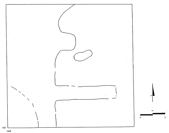
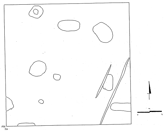
In our westernmost square on the west mound, 480, 1040, the clearest features are brick lined graves with alignments not far from east-west (Fig 11). These graves, like those on the east mound, are almost certainly Byzantine in date. Other features include plough marks which are certainly later in date than the brick-lined graves which they cut. Such plough marks have never been detected by us on the east mound. The graves are dug into a homogeneous soil with few or no clear features, and the interpretation must be that by far the greater part of the disturbance to the upper levels of the west mound was caused by agricultural activities in the centuries preceding the digging of the graves, perhaps during Hellenistic or Roman times. Clearance of two other squares on the west mound, 580, 1020 and 640, 960, also revealed no architecture, but several linear plough marks and series of pits, some of which are probably graves (Fig 12 and Fig 13).
References
French, D.H. (1962) 'Excavations at Can Hasan. First preliminary report, 1961', Anatolian Studies 12, 27-40.
Mellaart, J. (1964) 'Excavations at Çatal Hüyük, 1963. Third preliminary report', Anatolian Studies 14, 39-119.
Mellaart, J. (1965) ' Çatal Hüyük West', Anatolian Studies 15, 135-156.
Mellaart, J. (1967) Çatal Hüyük. A Neolithic town in Anatolia (London: Thames and Hudson).
Postgate, N. (1994) 'How many Sumerians per hectare? - Probing the anatomy of an early city', Cambridge Archaeological Journal 4,47-65.
| |
© Çatalhöyük Research Project and individual authors, 1994