ÇATALHÖYÜK 2004 ARCHIVE REPORT
| |
EXCAVATIONS
Overview – Shahina Farid
Areas of Excavation
Excavation took place in three areas of the East mound in 2004 (Fig. 2). The three areas were: 4040 Area, an area that was scraped in 2003 on the northern eminence of the mound; the TP Area, an area excavated by Team Poznań since 2001 at the crest of the mound; the South Shelter Area, an area excavated since 1995, incorporating the 1960s trenches and covered by a shelter constructed in 2002. The areas and structures within each area were targeted with specific aims for this current phase of excavation.
In terms of the excavation programme the research aims for the current 5-year phase of the project (2003-7) deal with the social geography of the settlement and larger community structure. We aim to answer the questions: how were production, social relations and art organised beyond the domestic unit? How did this organisation develop over time? Does the social geography of Çatalhöyük involve groups of houses clustered around dominant houses or is all social and economic life decentralised and based on equivalent domestic units of production?
In order to address these questions we moved away from detailed analyses of individual buildings, their construction, occupation and closure, which were the focus of the previous 5-year phase of work (1995-99, see forthcoming volumes), and we concentrated on large ‘neighbourhood' areas.
To this end the 4040 Area to the north of the east mound was scraped in 2003 and integrated with the area exposed by surface scraping in 1993-5 (Fig 8, Matthews 1996) . This exposed a large number of houses that defined groups of similarly aligned Neolithic houses possibly separated by ‘streets' or ‘alleyways'.
The aim over the course of the next 3 years is to excavate all buildings within the 4040 Area to their latest occupation horizon and to cover the area with a structure that will be open to visitors throughout the year, as well as providing cover for the archaeologists to continue excavating in the summer months (see South Area shelter). The next phase of work will then target specific buildings and spaces covering a range of building type and date.
4040 Area
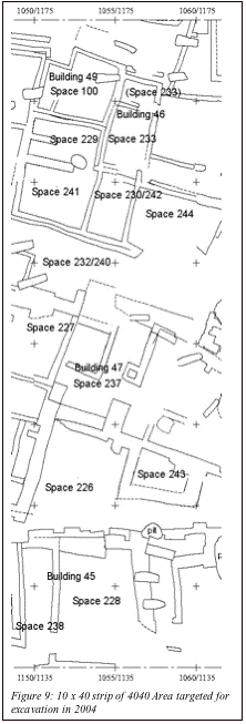
Accordingly, excavation in 2004 examined a 10x40m strip straddling a number of ‘zones' of structures separated by ‘streets/alleys'. The SW co-ordinate of the targeted strip is 1150/1135 (Fig. 9). From the north, a group of structures (Buildings 49, 46/48, Spaces 229, 241, 230, 242 and 244) lie on a similar alignment and appeared to form a unified zone. To the south of this ‘zone' was what appeared to be a ‘street' (Space 232/240) bounded to its south by a further zone of structures (Building 47 and Space 227). To the south again another ‘street' (Space 226) divided the southern-most building, a large structure (Building 45) lying on a slightly different alignment whose surface deposits indicated that it was heavily burnt.
Excavation started on the 27th June and ended 10th August. A temporary shelter was erected by 17th July which provided relief to the excavators from the relentless sun and allowed exposure of the wall plasters with minimised dehydration. Preliminary results of the season indicate that in fact the 10x40 strip straddled different Neolithic ‘levels'. Based on the pottery and chipped stone assemblages it appears that the latest structural activity is attributed to Level IV – III (no later than III) in Building 47 and Space 227. Building 45 to the south appears to date to Level V-IV and the northern zone of buildings appears to be Level VI or later based on assemblages from Building 49 and Space 229. Within this northern-most zone, the stratigraphy and wall relationships indicate that Buildings 49, 48 and Space 229 may be contemporary, followed by Space 241, then Space 242, then Space 244. Building 46, Space 230 and a skim of activity over Space 241 are later still.
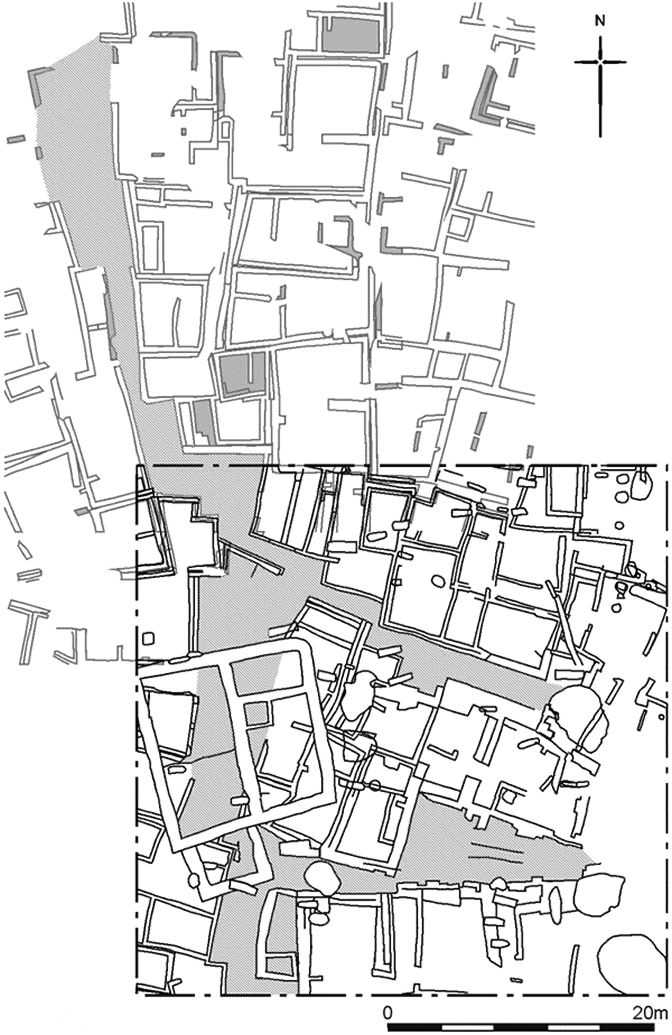
Figure 8: 4040 Area (bottom left hand) integrated with scrape area 1993-4
Immediately to the north of the 4040 Area, Buildings 1 and 3 have been dated to Level VII – VIII (see forthcoming volumes), although their chipped stone and pottery components suggest Level VI, similar to what we saw this season in the northern-most zone of the 4040. There is no reliable dating material from the ‘street' areas. These areas consisted of upper layers of compacted buff coloured clayey deposits overlying ‘midden' , the midden deposition and accumulation atypical of between structure midden areas excavated elsewhere on the site. It appears that Space 232/240 is a boundary between the earlier structures to the north and later structures to the south. The upper compacted buff coloured deposits of Space 232/240 may represent activity surfaces associated with the later structures (Building 47 and Space 227), and at this later phase only, could have been trodden paths. A similar sequence was present to the south in Space 226. The definition for ‘street' at Çatalhöyük is a constant route of communication between standing structures, one that is well established and static through time. Only through further excavation can we address whether these midden deposits in Spaces 232/240 and 226 are streets in this sense. For the moment we can find no evidence of trampling. They may in fact be the result of temporal shifts in areas of occupation and midden discard around zones of housing. Excavation concluded at different stages in each building and some aims of last year were revised in terms of focusing on the larger picture. Therefore, it was decided that Building 49, which last year was on a complete excavation track, would not be further excavated. Some buildings were partially excavated of occupation deposits, others were literally ‘emptied' of their Neolithic infill only. At the end of the season the strip was backfilled and will not be reopened until a permanent structure is constructed. The aim in 2005 is to explore another third of the 4040 Area so that the variation in date and function between apparently adjacent houses can be explored further. A 15m strip to the west of 2004 strip will be excavated and sampled. |
 |
South Area
To concur with our overall research aims, in the South area we can explore more fully the temporal processes that produce phases of settlement because the buildings remaining from the Mellaart and our excavations occur at different levels. Thus it is possible to examine the chronological development of houses in relation to each other from the very base of the mound. We therefore work towards expanding the area where we reached natural lake marl in 1999 (Farid 1999). This requires strategic planning of where and to what depth to excavate in order to achieve this in a safe and coherent manner. The trench where natural was reached in 1999 falls in the centre of the South Area (Fig.10). In order to extend this trench we need to excavate surrounding structures in a stepped manner. Therefore, in order to reach our ‘natural' target we have first to move further away from that focal point, but whilst doing so we will be fulfilling the aim of excavating a temporal sequence.
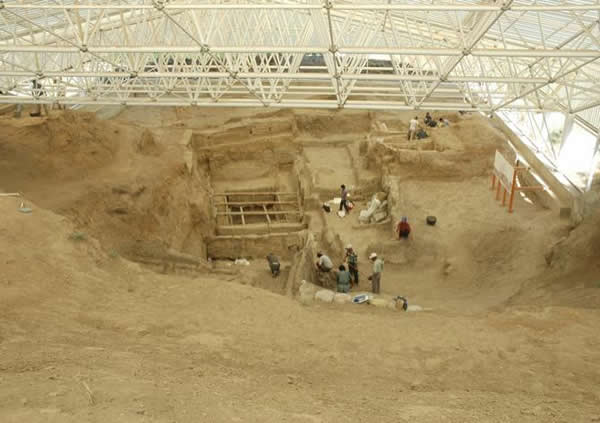
Figure 10: South Area. Braced shoring in the centre of the photograph is the location of where natural was reached in 1999. Photograph taken from South Summit. Building 42 is located upper left of the picture. Building 43 is located in the foreground of the shored area and Space 112 top right .
Four buildings were excavated in the South Area this season. At the very highest point to the east (see Fig. 10), in the South Summit Area (differentiated from the Summit Area, excavations conducted by the team from Thessaloniki University 1996-7), Building 44 is under excavation and is tentatively dated to Level IV-V. South Summit is located over a large section of stratigraphy which we hope to reduce over the course of the next few years.
To the centre of the southern side of the South Area, an upstanding ‘island' left from the 1960s, was excavated as Building 42(see Fig. 10), attributed to Level V. As far as Mellaart's reports indicate this building was defined as the southern limit of his excavation area and was not excavated. It appears on a plan of 1964 (Mellaart 1964, fig 11),and although structures to the north, east and west were excavated, this ledge was left. Consequently the walls to the north, east and west of Building 42 have eroded and collapsed since the 1960s. This building continues south beyond the modern shelter and consequently a strip of it was excavated as part of the foundation trench during the construction of the shelter structure (Farid 2002). It was from this building that one of the two figurines was found this year and the first plastered and painted human skull at Çatalhöyük.
The practice of modelling facial features in plaster on skulls is generally known from Early Neolithic sites in the Levant, such as Jericho and ‘Ain Ghazal, but in Anatolia it has hitherto only been found at the Late Neolithic site of Köşk Höyük where 11, plastered but unpainted, skulls have been recorded (Bonogofsky 2004).
The skull found at Çatalhöyük was from a grave context (see Building 42, this report), and was held in the arms of a woman against her chest (see Fig. 3). The skull was modelled in a powder-like lime plaster from brow to chin (the lower jaw was however, displaced) and covered with a red pigment (Fig. 11). From preliminary observations it appears that the ‘colour' in the eye sockets was layered with plaster, the implication being that the skull was remodelled more than once. However this was a very preliminary analysis as we found the burial in our last week of excavation. Precious time was therefore spent in in situ conservation, lifting and preparations for display in the Konya Archaeological Museum. The decision to remove this ‘artefact' from its primary context was conditioned by a number of factors: access to this context was difficult being on the edge of a ‘plinth' of strata. The burial had been riddled by mole rats leaving unstable voids; it would have taken weeks to conserve and lift the complete skeleton with the skull and we did not have the option of leaving it in situ for the following season. We therefore treated the skull as a burial artefact, which also meant we had to sacrifice some of the skeleton that held the skull in its arms.
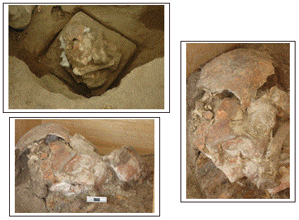
Figure 11: Top-In situ defined area for block lifting. Right-skull in profile. Bottom left-side on view
On the northern side of the South Area our original limit of excavation (planned as a 20 x 20 m Area, Farid 1995) was extended when the shelter was planned. Consequently a row of Level VII buildings, half-sectioned between 1995-7 can now be fully excavated. For this season, Space 112 (Farid in press) was chosen. This was excavated by Mellaart in 1963 as Shrine E.VII.9 and most of the occupation sequence of the building had been removed by Mellaart to the horizon of the underlying building infill. However remnants of floor deposits and all cut features were left and were excavated by the current team in 1995-7. The cut features consisted of post-retrieval pits and 11 burials. This year's work added 4 to the corpus of burial data with a final count of 15 in an area of just 4.3m N-S x c.2.9m E-W. This years burials include the first human buried with a complete lamb at Çatalhöyük.
The fourth building we excavated this year was located towards the centre of the South Area close to where we propose to excavate down to natural (see Fig. 10). This building was originally excavated in the 1960s by Mellaart as E.VIII.27 and is located immediately to the east of his shrine 10 sequence, our Building 17, Level IX (Farid in press). The only publication from the 1960s which relates to this building is a plan showing the internal configuration (Mellaart, 1966). Since the 1960s only a small section of this building was exposed and recorded in section in 1995 (Matthews & Farid 1996)
In addition to the excavations in the South Area we exposed, treated and lifted the section of wall painting that had been revealed at the end of the last season in Building 2 (Farid 2003). Located in a shallow upper niche, centrally located in the north wall of Building 2, the painting is an abstract design of red on white with traces of black strokes too.
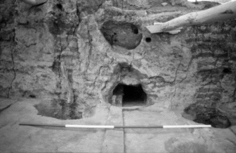
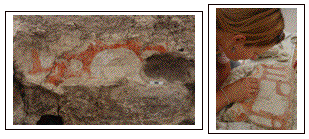
Figure 12:Top-North wall of Building 2. The wall painting was found in the upper niche. Bottom: left-area exposed end of last season, right-lower section lifted this year |
TP Area
The team from Poznań, Poland, continued excavations at the highest point of the East Mound (see Fig. 2). This area was targeted to investigate the latest levels of the site, which were neither represented in our excavations on the northern eminence of the mound nor in the South Area. TP Area is located immediately to the east of where Mellaart had excavated Levels I-IV (Farid 2000). After three seasons of excavating through classical activity, the team has exposed a complex sequence of midden and constructional layers placed on a structure that may be remains of a fallen roof of a late Neolithic building.
Revised Methods of Excavation and Sampling
Having spent the first phase of excavations employing detailed analysis on the sequences of individual buildings (Farid 2000b), we began this new phase with revised methods of excavation and recording. In particular, the methods now involve more selective use of intensive on-site sampling. The methodology evolved through the season and with problems and tensions between excavation and laboratory teams. The process was a good reminder of why excavation at Çatalhöyük is a slow business and that there are no quick excavation solutions which allow for the detailed scientific data that are needed for the interpretation of a site of this type.
By the end of the season we had reached a new consensus on how to proceed and these new methods and sampling procedures will be ready in place for the 2005 excavations. The methods are outlined to aid the reading of the following excavation reports.
Initially we introduced a three level excavation track. The first involved a ‘fast track', ‘medium track' and a ‘full-on sampling track'
FAST TRACK – excavation of spaces and buildings where the complete sequence is obviously lost through erosion, previous excavations or bisection by the location of trench edges. This meant that there were no flotation samples, no archive samples, no samples for analyses, no dry sieve (finds were hand picked). XYZ co-ordinates were taken only on very specific materials. Short cuts were taken on field recording sheets where information could be retrieved at post-excavation stage (cross-references etc.).
MEDIUM TRACK – was introduced where a complete sequence of a space or building was represented. Flotation and archive samples were taken and dry sieving took place. Specific samples were taken at the excavators' discretion or with laboratory teams' advice. Floors were not gridded and sampled.
FULL-ON SAMPLING – the complete suite of samples taken in a representative sample of spaces and buildings on spatial and temporal dimensions of variation.
Mid-season we re-addressed the tracking system as teams felt that crucial data was being lost through fast tracking. The result of these discussions and negotiations was that we abandoned ‘medium track' and ‘fast track' was modified.
FAST TRACK - A flotation sample of 30 litres was taken from ‘middens', ‘rake out material' (deposits associated with and around ovens and hearths).'burial fills', ‘cut fills' (post retrieval pits, shallow pits and scoops, etc.). No archive samples were taken and finds were hand picked only. Discretionary samples were taken for deposits such as particularly rich botanical deposits, phytoliths in a burial in association with a cache, concentration of microfauna, etc. etc. A small block of all brick types and a sample of all wall plasters were collected. Micromorphology blocks were taken as often as possible.
FULL-ON SAMPLING – as above
By the end of the season we decided on a system which addressed everyone's concerns.
All excavated deposits would be sampled for archive and flotation and dry sieving except
large and/or sterile deposits such as ‘building fills', ‘floors / floor make-up' and ‘bin fills' (we know from previous work that these deposits do not relate to use). These latter deposits will be sampled for archive and flotation and 30 litres only would be dry sieved. Other samples would be assessed as work progresses.
Excavation Teams
The 2004 excavation team consisted of contract excavators employed from the UK, Turkey, the US, Serbia, Bulgaria, Romania; University funded field schools (Team Poznań, University of Poznań and the Polish Academy of Science, Stanford University Field School, Berkeley University Field School); funded individuals from universities in the UK, US, Iran, Sweden, Denmark and Turkish students from different universities supported by the Çatal Project. The aim is always for students to work along side professional excavators to gain a good and thorough grounding in excavation skills, recording and integrated interpretation. Excavation teams are therefore grouped based on experience with specific aims for the seasons work accounted for. For reference and report writing purposes teams are referred as TP (Team Poznań), Stanford Field School, Berkeley Field School whilst contract staff are cited as Çatal core team.
2004 sezonuna genel bir bakış – Shahina Farid
Kazı Alanları
2004 sezonundaki kazı çalışmaları doğu höyüğünün üç kısmında yer aldı (Ek. 2). Bu üç alandan ilki höyüğün kuzey tepesinde bulunan ve 2003 yılında kazılmaya başlanan 4040 alanı, ikincisi, höyüğün merkezinde bulunan ve 2001 yılından beri Poznan ekibi tarafından kazılan TP alanı, son olarak da üçüncüsü, 2002 yılında bir çatı yapısı ile üzeri örtülen ve 1960 açmalarının da içine dahil olduğu, 1995 yılından beri kazılan Güney Alanı. Tüm bu alanlarda yapılan çalışmalar, kazının bugünkü evresi için belirli amaçlar hedefledi.
Kazı programına göre, projenin şu andaki 5 yıllık araştırma safhası (2003-7), yerleşimin sosyal coğrafyası ve geniş toplum yapısını incelemeyi amaçlamaktadır. Şu sorulara cevap bulmayı amaçlıyoruz: Üretim, sosyal ilişkiler ve sanat evcil birimin ötesinde nasıl organize edilmişti? Çatalhöyük'ün sosyal coğrafyası, kümelenmiş ev gruplarını kentin önemli evleri etrafında mı topluyor? Yoksa tüm sosyal ve ekonomik yaşam eşit bir biçimdeki evcil üretim birimleri tarafından mı yürütülüyor?
Bu sorulara cevap bulmak amacıyla, ayrı bina yapılarının, yerleşim ve terketme safhalarının geçtiğimiz beş yıl boyunca yaptığımız ayrıntılı analizine bir ara vererek (1995-99, çıkmak üzere olan ciltlere bakınız) daha geniş bir çevreye konsantre olmaya başladık.
Bu yüzden doğu höyüğünün kuzeyindeki 4040 Alanı 2003 yılında kazılmaya başladı ve 1993-95 yılları arasında yapılan yüzey kazısında (Ek. 8, Matthews 1996) ortaya çıkarılan alanla birleştirildi. Bu çalışma, büyük ihtimalle ‘caddeler' ya da ‘dar sokaklarla' birbirlerinden ayrılan, benzer şekilde sıralanmış bir çok sayıda Neolitik ev ortaya çıkardı.
Önümüzdeki üç sene boyunca 4040 alanındaki tüm binaların en geç yerleşme tabakalarına ulaşarak, alanı hem sene boyunca ziyaretçilere açmak hem de arkeologların yaz aylarında rahatça çalışmalarını devam ettirmek için bir çatı yapısıyla örtmeyi amaçlamaktayız (Güney Alanı çatısına bakınız). Çalışmalarımızın diğer safhasında da bir sıra bina tipi ve tarihlemeyi kapsayan belli binaların ve alanların araştırılmasını hedefleyeceğiz.
4040 Alanı
2004 sezonu kazı çalışması sırasında ‘cadde ve dar sokaklarla' ayrılmış olan bir sıra yapı ‘bölgesinin' ortaya çıkarıldığı 10x40m uzunluğunda bir şeridi kazdık. Güneybatı doğrultusunda uzanan bu şerit 1150/1135 olarak numaralandı (Ek. 9.). Kuzeyde, birleşik bir bölge formunda görülen benzer şekilde sıralanmış bir yapı grubu (Bina 49,46/48, Alan 229,241,230,242 ve 244) bulunmaktadır. Bu ‘bölgenin' güneyinde bulunan bir cadde (Alan 232/240) güney yönüne daha başka bir yapı bölgelesiyle bağlanmaktadır (Bina 47 ve Alan 227). Yine güneyde, güneydeki bir çok binayı bölen bir ‘cadde' üzerinde biraz farklı bir şekilde hizalanmış büyük bir bina (Bina 45) ortaya çıkarttık. Bu binada bulunan yüzey dolguları, binanın büyük bir yangına uğradığını kanıtladı.
Kazı çalışması 27/6 tarihinde başlayıp 10/8 tarihinde bitmistir. 17 Temmuz'da dikilen geçici çatı hem kazı ekibinin güneş altında rahatça çalışmasını hem de ortaya çıkarılan duvar resimlerinin kurumadan korunmasını sağladı. Sezonun ilk sonuçları yukarıda bahsedilen 10x40m uzunluğundaki şeridin farklı Neolitik ‘tabakalara' ait olduğunu gösterdi. Seramik ve işlenmiş taş tümlemelerine göre Bina 47 ve Alan 227'deki en geç yapısal aktivite Tabaka IV-III (III den daha geç değil) arasına tarihlenmektedir. Kuzeye doğru yönlenen Bina 45 Tabaka V ve VI ya tarihlenirken, Bina 49 ve Alan 229'daki yapı topluluklarına göre, binaların kuzey bölgesi Tabaka VI ve sonrasına tarihlenmektedir. Bu en kuzey bölgesindeki Bina 49,48 ve Alan 229'un stratigrafi ve duvar ilişkilerine bağlı olarak aynı döneme ait oldukları ve daha sonradan da Alan 241,242 ve 246'ın geldiği düşünülmektedir. Bina 46 ve Alan 230 ve Alan 241'de görülen bazı aktiviteler yine geç bir tabakaya tarihlenmektedir.
4040 Alanı'nın hemen kuzeyindeki Bina 1 ve 3, seramik ve işlenmiş taş tümlemelerine göre Tabaka VI tarihini verse de, bu sezon 4040'nin en kuzey bölgesindeki yapılara benzer olarak Tabaka VII-VIII arasına tarihlenmiştir (çıkmak üzere olan ciltlere bakınız).
‘Cadde' diye adlandırılan alanlarda güvenilir bir tarihleme materyaline rastlanmamıştır. Bu alanlar ‘çöplük dolgusu' üzerine yayılmış olan sıkıştırılmış, soluk sarı renkli kil dolgusunun üst katmanlarından oluşmaktadır. Bu alandaki çöplük dolgusu ve toplanmış dolgular, kentin diğer kısımlarında kazılan yapı ve çöplük dolgusu ile benzeşmektedir.Alan 232/240'ın güneyin daha geç yapılarıyla kuzeyin daha erken yapıları arasında bir sınır oluşturmaktadır.Alan 232/240'ın üst katmanlarındaki sıkıştırılmış soluk sarı renkli dolgular, daha geç yapılarla ilişkisi olan aktivite yapılmış yüzeylerin bir açıklaması olabileceği gibi sadece bu geç evrede görülen bir yürüme yolu da olabilir.Buna benzer bir sıralama Alan 226'nın güneyinde de görülmektedir. Çatalhöyük'deki ‘cadde', ayakta kalan yapılar arasında bulunan ve uzun bir zaman süreci içinde değişmeden kalan bir alan anlamında kullanılmaktadır.Alan 232/240 ve 226 çöp dolgusunun cadde olup olmadığını ancak ilerde yapılacak kazı çalışmaları sonunda belirleyebiliriz.Şu an için herhangi bir yürüme yolu izine rastlayamamaktayız. Bu caddeler, ev bölgelerini çevreleyen yerleşim ve çöp atık alanlarındaki geçici değişmelerin bir sonucu da olabilir.
Kazı çalışması her binada farklı bir aşamada tamamlanırken, geçen senenin bazı amaçları-örneğin, daha geniş bir alana konsantre olunması- gözden geçirildi. Bu yüzden geçen sene tam gaz kazılan Bina 49'un daha fazla kazılmamasına karar verildi. Bazı binaların yerleşim dolguları kısmen olarak kazılırken, diğerleri sadece Neolitik döneme ait yıkıntı dolgularından temizlendi. Sezonun sonunda 10x40 m uzunluğundaki şerit dolduruldu ve bu şeridin binalar arasındaki gerçek rolü ortaya çıkarılıncaya kadar açılmamasına karar verildi.
2005 sezonunda, 4040 Alanı'nın diğer bir kesimine konsantre olmayı amaçlıyoruz. Böylelikle, birbirine birleşik binalar arasındaki tarih ve kullanılış farklılıklarını daha fazla inceleyebiliriz. 2004'de bulunan şeridin batısına doğru yönlenen 15m'lik bir şerit kazılmasını ve örnek alınmasını planlamaktayız.
Güney Alanı
Genel araştırma amacımızı yerine getirmek için, Mellaart'ın ve şu andaki kazılarımızın ortaya çıkardığı farklı tabakalardaki binaların Güney Alanı'ndaki yerleşim evrelerini belirleyen geçici süreçleri daha derin bir şekilde inceleyebiliriz. Böylelikle höyüğün tabanından başlayarak binaların kronolojik gelişimleri ve birbirleriyle olan ilişkilerini araştırabiliriz. Bu yüzden kazılarımızı, 1999'da ulaştığımız ve tabanında doğal marn ortaya çıkan erken Holosen göl yatağına doğru genişletme yolunda çalışmaktayız (1999 Arşiv Raporu). Bu çalışmayı güvenli ve tutarlı bir şekilde yapmak için nereyi ve hangi derinlikte kazacağımıza dair stratejik bir plan gerekmektedir.1999'da ulaştığımız doğal alandaki açma Güney Alanı'nın (Ek. 10) merkezinde bulunmaktadır. Bu açmayı genişletmek için etrafındaki yapıları birer birer kazmak durumundayız. Bu yüzden ‘doğal' hedefimize ulaşmak için ilk olarak odak noktamızdan uzaklaşarak aynı zamanda geçici bir dönem sıralamasını ortaya çıkarma amacımızı yerine getirmiş olacağız.
Bu sezon Güney Alanı'nda dört bina kazıldı. Güney Summit Alanı'nın doğuya bakan en yüksek noktasındaki (Summit Alanı'ndan farklı olarak, 1996-7 arasındaki kazılar Selanik Üniversitesi'nden bir ekip tarafından yapılmıştır). Bina 44'un kazısına devam edilerek bu binanın Tabaka IV-V arasına tarihlendiği düşünülmektedir. Geniş bir stratigrafi parçasının üzerinde yer alan Güney Summit'i önümüzdeki 1-2 yıl içinde küçültmeyi planlıyoruz.
Güney Alanı'nın güney doğrultusunun merkezindeki 1960'lardan kalma bir ada, Bina 42 olarak kazılmış ve Tabaka V'e tarihlendirilmiştir. Mellaart'ın raporuna göre bu bina Mellaart'ın kazı alanının güney sınırı olarak belirlenmiş ve bu yüzden kazılmamiştı. Bu bina 1964 yılına ait bir planda çizilmiş (Mellaart 1964, fig 11) ve kuzey,doğu ve batıdaki yapılar kazıldığı halde, bu yapı kazılmadan bırakılmıştır. Sonuç olarak Bina 42'nin kuzey,doğu ve batı duvarları 1960'lardan bu yana aşınıp yıkılmıştı. Bu bina güneye, modern çatının ötesine doğru uzandığı gibi, bu binaya ait olan bir şerit, çatı yapısının inşası sırasında bir temel açması olarak kazılmıştır (Farid 2002). Bu sene bulunan iki figürinden biri ve Çatalhöyük'teki ilk boyanmış alçılı insan kafatası bu binada ortaya çıkarıldı.
Güney Alanı'nın kuzeyindeki kazımızın önceden belirlediğimiz sınırı, çatının planlanması sırasında genişletildi (20x20m boyutunda bir alan olarak planlandı, Farid 1995). Böylelikle 1995-7 yılları arasında yarım olarak kesitlenmiş bir sıra Tabaka VII'ye ait bina şu anda tamamen kazılmaya hazırdır. Bu sezon Alan 112 (Arşiv Raporları ve çıkmak üzere olan ciltler) seçildi. Bu alan 1963'de Mellaart tarafından Tapınak E.VII.9 olarak kazılmış ve binanın yerleşim sıralamasının çoğu, Mellaart tarafından binanın yıkıntı dolgusunun altındaki düzlüğe taşınmıştı. Ancak taban dolgusunun kalıntıları ve tüm kesitli alanlara dokunulmamış ve 1995-7 yılları arasında şu andaki ekip tarafından kazılmıştır. Kesitli alanlar 11 gömü ile çukurlardan oluşmaktadır. Bu seneki çalışmalar gömü verisine 4 gömü eklerken, 4.3m güney-kuzey x c.2.9m doğu-batı doğrultulu bir alan 15 gömü ekledi. Gömüler, Çatalhöyük'te bir koyunla gömülmüş ilk insanı da içermektedir.
Bu sene kazdığımız dördüncü bina, doğal tabana inmeyi amaçladığımız yere yakın olan, Güney Alanı'nın merkezinde yer almaktadır.Bu bina ilk olarak 1960'larda Mellaart tarafından E.VIII.27 olarak kazılmış ve hemen Tapınak 10'un ve şu andaki ekibin kazdığı Bina 17,Tabaka IX'ın doğusunda bulunmaktadır (Arşiv Raporları ve çıkmak üzere olan ciltler). 1960'lardan kalan ve bu binayla ilgili bilgi veren tek yayım, dahili konfigürasyonu (Mellaart, 1966) gösteren bir plandır. 1960'lardan beri bu binanın sadece küçük bir kesiti ortaya çıkarılmış ve 1995'deki kesitin içinde kaydedilmiştir (Matthews et al 1996).
TP Alanı
Polonya'dan gelen Poznan ekibi doğu höyüğünün en yüksek noktasında çalışmalarına devam etti. Bu alan ne höyüğün kuzey tepesindeki ne de Güney Alanı'ndaki kazılarımız tarafından araştırılan, kentin en geç tabakalarına ulaşmayı amaçlamaktadır. TP alanı Mellaart'ın kazdığı Tabaka I ve II'nin hemen doğusunda bulunmaktadır (Farid 2000). Üç sezondur kazdıkları klasik yerleşimin sonunda ekip, geç Neolitik bir binanın yıkılmış çatısının kalıntıları olduğu düşünülen ve bir yapı üzerine yerleştirilmiş karışık bir çöp dolgusu ve yapı katmanları sıralaması ortaya çıkardı.
Yeniden gözden geçirilen kazı ve örnek alma teknikleri
Kazının ilk evresinde yaptığımız ayrı bina sıralamalarının detaylı analizinden (Farid 2000b) farklı olarak, bu yeni evreye yeniden gözden geçirilmiş bir kazı ve kayıt sistemiyle başladık. Şu andaki metod, ayrıntılı bir şekilde yapılan örnek alma işleminin daha seçici bir şekilde yapılmasını içermektedir. Bu metod, sezon boyunca kazı ve labaratuar ekipleri arasındaki tartışmalar sayesinde daha da gelişerek, Çatalhöyük'deki kazıların niye yavaş olduğunu ve kentin yorumlanabilmesi için gerekli olan ayrıntılı bilimsel verilerin toplanabileceği başka bir hızlı kazı metodunun olmadığını bize bir kere daha gösterdi.
Sezon sonunda bu yeni metodlarla nasıl çalışılacağı ve örnek alma sistemiyle ilgili yeni kararlar aldık. Yeni çalışma yöntemi 2005 yılı kazılarında uygulanmaya başlanacak. Aşağıda açıklanan bu metodlar, kazı raporlarının anlaşılmasında da yardımcı olacaktır.
Başlangıç olarak üç ayrı kazı metodu sunduk. ‘Hızlı kazı', ‘orta derecede kazı' ve ‘tüm örneklerin alındığı kazı' metodu.
HIZLI KAZI – Bütün bir dönem sıralamasının erozyon, önceki kazılar ve açma kenarlarının yönü tarafından ikiye bölünerek kaybolduğu kazı alanları ve binalar. Bu yöntem , yıkama (flotation), arşiv, analiz ve kuru elek örneğinin alınması gerekmediği anlamına gelmektedir (Buluntular elle toplanır). XYZ kordinasyonları sadece belirli materyallarden alınmıştır. Kazı sonrasında bilgi almak için doldurulan kayıt formlarında kestirme yollar kullanılmıştır.
ORTA DERECEDE KAZI-Bir bina veya alana ait bütün bir dönem sıralaması takip edildiğinde. Yıkama (flotation), ve arşiv örnekleri alınarak kuru eleme işlemi yapıldı.Belli örnekler kazıcılar önemli gördüklerinde ya da labaratuar ekibinin tavsiyesi üzerine alındı. Tabanlardan örnek alınmadı.
TÜM ÖRNEKLERİN ALINDIĞI KAZI-Bir bina veya alana ait tüm örneklerin çeşitli boyutlarda alınması.
Sezon ortasında, kazıcılardan ve labaratuar ekibinden bazı önemli verilerin hızlı kazı sırasında kaybolduğu şikayeti geldi. Yapılan tartışmalar sonucunda ‘orta derecede kazı' metodu kaldırılarak, ‘hızlı kazı' metodunda değişiklikler yapıldı.
HIZLI KAZI-30 litrelik bir yıkama örneği ‘çöplük'den, ‘fırın ve merkezi fırın dolgusundan, ‘gömü dolguları ve ‘çukur dolgularından alındı. Hiç arşiv örneği alınmadı ve buluntular elle toplandı. Alınması gereken örnekler özellikle zengin bitkisel dolgulardan, gizli gömüyle ilişkisi bulunan phytolithlerden,mikrofauna topluluklarından vs.vs. Tüm tuğla formlarının ufak bir kısmı ve tüm duvar alçılarının bir parcası da örnek olarak alındı. Mikromorfoloji blokları da her zaman olduğu örnek olarak toplandı.
Sezon sonunda herkesin görüşüne uygun olan bir sistem kullanmaya karar verdik.
Kazılan tüm dolgulardan arşiv,yıkama (flotation) ve kuru eleme için örnek alınırken, ‘bina dolgusu, ‘tabanlar' ve çöplük dolgusu (önceki çalışmamızdan bu dolguların kullanıma ait olmadığını biliyoruz) gibi büyük ve temizlenmiş dolgulardan örnek alınması gerekmemektedir. Bu dolguların arşiv ve yıkama (flotation) için örnekleri alınırken, sadece 30 litrelik kısımları kuru eleme işlemi için kullanılacaktır. Diğer örnekler çalışmalar devam ettikçe değerlendirilecektir.
Kazı Ekibi
2004 sezonu İngiltere, Türkiye, Amerika, Sırbistan, Bulgaristan, Romanya'dan katılan sözleşmeli arkeologlardan, Üniversite tarafından desteklenen okullardan (Poznan ekibi,Poznan Üniversitesi ve Polonya Bilim Akademisi, Stanford Üniversitesi ve Berkeley Üniversitesi), İngiltere, Amerika, İran, İsveç, Danimarka'daki üniversitelerden sponsorluk alan kişilerden ve Çatal projesinin desteklediği farklı üniversitelerden gelen Türk öğrencilerden oluşmuştur. Genel amacımız öğrencilerin profosyonellerle birlikte çalışarak derin ve güçlü bir kazı becerisi, kayıt yapma ve bilgileri bütünleyerek yorumlama yeteneği kazanmalarını sağlamaktır.Bu yüzden kazı ekipleri deneyimlerine ve o sezonda ulaşılması gereken amaçlara göre gruplanmaktadır.Referans ve rapor yazma işlemleri için ekipler TP (Team Poznan), Stanford Arazi Ekibi, Berkeley Arazi Ekibi diye isimlendirilirken, sözleşmeli ekip Çatalhöyük'ün ana ekibi olarak geçmektedir.
| |
© Çatalhöyük Research Project and individual authors, 2004