ÇATALHÖYÜK 1995 ARCHIVE REPORT
    |
Mellaart Area 1995. Summary Report.
Shahina Farid
1. Abstract:
During the six week season which was conducted from 19th August to 30th September, the central area of the trench was excavated of the backfill and previously excavated buildings were defined. All exposed section drawings were drawn, and excavation in Courtyard 15 and House 2 was started. The stratigraphy exposed and recorded correlates with Mellaarts Levels VI - X.
2. Research:
One of the research objectives at Catalhoyuk is to investigate the presence of any pre-neolithic activity on the site. This investigation is being conducted within the area of Mellaart's previous excavations, for ease of access as well as to locate a 'deep sounding that he had excavated through early levels in Shrine 1.
3. Background:
Mellaarts excavations conducted in the early 1960s were located on the S.W side of the neolithic mound. During the course of his work, he identified and interpreted 12 levels of construction horizons. In 1963 Mellaarts aim was to investigate early activity in a deep sounding that he located in Shrine 1 which had been excavated to Level X. His records state that he reached a flood deposit horizon 5m below the level of the surrounding plain.
Mellaart did not conduct a 1964 season at Catalhoyuk.
By 1965 the 'deep sounding' was in a state of collapse, the rising water levels had turned the hole into a stagnant pool and a dead sheep was rotting at the bottom. Mellaart was forced to backfill the hole and begin again by relocating his 'deep sounding'.
1965 was to be Mellaarts last season at Catalhoyuk and his aim to explore the early levels were never realised.
4. 1995 Trench Location
The trench, MELL'95, was located within Mellaarts area of excavation as the results could be tied in with his stratigraphic sequence. As its location was also on the edge of the mound the potential depth of stratigraphy would be less to excavate.
For safety considerations the trench was positioned away from the old high sections and was excavated by stepping in the sides by 1m. at every 1.2m depth. In order to excavate a reasonable sized basal area an area of 20m square was opened at the top.
5. Methodology:
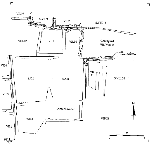
Within Mellaarts area of excavation a 20 x 20m area was positioned and as the vegetation and backfill was cleared the published plans in Mellaarts preliminary reports were used to correlate the excavated houses and shrines with the buildings on the ground. The trench encompasses the approximate position of Shrine 1 and Shrines 8, 9 and 10, parts of Shrines 12, 14, 25 and 27, Houses 2, 16, and 28, and parts of Houses 3, 4, 5, 6, 7, 12, 19, Courtyard 15 and the ante-chamber/shaft to Shrine 8. These buildings had been excavated to different levels. (see figure 1)
After the systematic clearing of erosion and backfill from within the buildings' to the horizon or close to where Mellaart had excavated to, the wall faces of the buildings were cleaned and their sections drawn and recorded stratigraphically and photographically. The interpreted sections were compared to and tied in with Mellaarts reports and excavation of two areas was begun.
The definition of 'house', 'shrine' and 'courtyard', the numbering sequence and the construction levels interpreted by Mellaart have been continued through this seasons work for ease of reference.
6. Results:
The section drawings of houses 4, 5, and 6 located on the SW edge of the trench were recorded as level VII, based on Mellaarts records. The internal facing walls to House 4 were heavily scorched through fire. House 6 walls retained their plaster rendering and in the NE corner of the west facing wall was the remnants of a feature, identified as a grave, based on the artefacts recovered from it.
House 12 had been excavated to Level VIII and backfilled, but the level at which this seasons recording started was Level VII. The full extent of this building was not revealed as it lay beyond the limit of excavation to the west. Towards the NE corner of the west facing wall is a blocked door/crawlhole. This is defined by traces of a plaster lining and because the blocking bricks differ from those of the Level VII walls. This suggests that the blocking took place at a later construction phase, possibly that of Level VI. Blocking would presumably be necessary in order to avoid subsequent subsidence from the weight of the succeeding walls.
Blocking is also visible in house 2 which was excavated to Level VII. Remnants of previously excavated Level VII floors were concentrated around the blocked door/crawlhole. These comprised fine laminated plaster floors interfaced with fine mud plaster. These appeared uneven and patchy, presumably through wear given the location, and were traceable up to and presumably below the blocking. In the NW corner of the house was a shallow, square basin-type feature which the plaster floors respected and lipped up to. This had a fill of ash and plaster and a large waterworn boulder fragment. Its function at this stage of incomplete excavation is unclear. In the NE area of the room traces of deposits appear to be 'midden' deposits, but were not investigated this season. In the west facing wall of House 2 is another possible blocking but this was not satisfactorily identified this season and as House 16 to the E was not worked in, a continuation of this blocking was not established.
Although House 16 was not fully cleaned, enough was revealed to indicate that the deposits were of a 'midden' composition. Mellaart records this area as a 'courtyard' in Level VII. (Were then these areas originally domestic houses, abandoned and used as refuse areas over a period of abandonment or were they deliberately backfilled with 'refuse' immediately prior to redevelopment/is the refuse/midden in-situ or redeposited?).
The possibility that Houses 12, 2 and 16 were interlinked at Level VII is suggested not only by the door/crawlholes through Houses 12 and 2, and possibly 2 and 16, but also because they share party walls.
To the E of House 16, Courtyard 15 was cleaned. Mellaart records this as a 'courtyard' in Levels VI and VII, but did not excavate the area. The top surface is heavily eroded on a slope eastwards which may have been a result of Mellaarts excavation work but it is clear from preliminary cleaning of this building that the area comprises more than one house. Initial excavation this season was conducted in a 1m square area in the NW corner to determine the nature of the deposits, whether they represent slow accumulation or homogenous backfill. The area excavated was too limiting to make any firm conclusions but initial investigation revealed several deposits, rich in debris.
Shrines 10 and 27 had been excavated to Level VIII but were cleared of erosion to just above the horizon of where Mellaart stopped. Overall the sections reveal Levels VII and VIII walls, differentiated by their very clear change in brick and mortar colour. Where the two buildings abut one another, Mellaart records a westward drop in terrace level. This is apparent in the heights of the level VIII walls, those of Shrine 27 being higher than in Shrine 10, if the change in brick colour denotes a change of phase.
The north facing sections of Shrines 27 and 10, and the east facing section of Shrine 27 also reveal the unexcavated Level VII deposit/fills within the buildings to the south.
The east and south facing section of Shrine 10 are heavily eroded and complex, and less easy to interpret without excavation. The south facing section appears to comprise several levels of wall and the east facing section reveals part of an ante-chamber west of Shrine 10. Mellaart excavated this to Level VII which in plan comprised a long narrow room with a small square room at its southern end. These additional rooms present many plastered wall faces in section that cannot be made sense of until excavation in plan.
Shrines 1 and 8 in the centre of the trench, had been excavated to Level X by Mellaart and then the 'deep sounding' excavated through Shrine 1. These buildings were not fully emptied of their backfill this season because of time restrictions and also to avoid high standing sections.
The dividing walls to the shrines had either been removed by Mellaart or had collapsed during the work. Walls of Levels VII and VIII were revealed and also possibly a Level VI wall to the south of Shrine 8. This will not be established until the area to the south is excavated. The north facing section of Shrine 8 has a blocked door/crawlhole, possibly blocked in level VII, and the west facing section has an overhang in the wall at the horizon of the two levels of wall construction. The overhang has a continuous plaster rendering, suggesting that whilst additional walls were constructed over the top of earlier walls, partial extant heights of the earlier walls were used in conjunction with the later additions. The NE corner of Shrine 8 is where four structures meet, and comprises what appears to be several wall constructions. At this stage of the excavation these walls do not conform to a coherent stratigraphical sequence.
The Level VIII wall of Shrine 8 is an anomaly in that, to the north and east, the bricks are a very distinct dark grey with white mortar bonding, but the southern wall bricks are bright red-orange with a white mortar bond. The change occurs in the SE corner of the Shrine which has not yet been excavated.
In the SW corner of Shrine 1 is another overhang with a continuous plaster rendering. It is unknown whether the overhangs represent constructional misalignments, moulded features or the imitation of an early construction technique of wooden post and beam construction, as suggested by Mellaart.
The east facing section has large areas of extant plaster within which a small area revealed red painted plaster with fragment of a trellis type motif and rosette or sunburst motif.
To the south of Shrine 1 is House 3, which was excavated to Level VIB, and south of Shrine 8 lies the ante-chamber/shaft to the shrine. Only a small length of the north facing section to the ante-chamber was recorded. It comprised numerous brick types and sizes. Regularly spaced 'joins' in the mortar were filled with plaster, giving the appearance of brick joins. They could represent some form of keying for the plaster facing or could indicate a mortar laying technique.
Overall, the sections revealed that the houses were constructed with back-to-back walls with fill/packing in the gaps. In some areas the fill/packing looks deliberately laid, whilst in others it appears to have accumulated slowly. A third type of this fill/packing may represent earlier stratigraphy cut by the construction cut(s) of the wall(s).
| |
© Çatalhöyük Research Project and individual authors, 1995