ÇATALHÖYÜK 1994 ARCHIVE REPORT
    |
Animal Bone Report
Louise Martin
During the 1994 field season, work on the animal bones concentrated in three main areas:
- the east mound surface survey (2x2m2) collection;
- the east mound sub-surface scrape (10x10m2) collection;
- the west mound surface survey (2x2m2) collection. This report presents the preliminary results of the study of this surface material. Worked bone recovered from the surface scraping was also catalogued, and animal bone material from the 1960's excavations at Çatalhöyük - housed in the Konya Museum - was given a preliminary examination; these aspects of the work are described in a separate forthcoming report.
Animal bone material from the surfaces of archaeological sites has generally not received much attention, mainly because it cannot provide chronological or typological information. Being a 'natural' category of finds, the information which animal bones provide is limited unless their depositional history is understood.
The purpose of studying the surface collections from Çatalhöyük is to attempt to elucidate site-formation and post-depositional processes on the site, by firstly exploring patterns in the distribution and condition of the material, and secondly by comparing these patterns with those of other finds classes (e.g. chipped stone, pottery), site topography, features and deposits. This second approach - the integration of the animal bone data with other information - is not yet complete; hence, what follows is mainly a description of the pattering within the faunal data.
The east mound
Surface survey
The systematic sampling of the surface of the mound (by sieving 36 litres of deposit at 20x20m intervals through a 5mm mesh) produced large quantities of animal bone material. Following the methodology laid down in 1993, bone fragments were separated into size categories (of under 2cms length and over 2cms length), and each size class was weighed. Further information was recorded on the general nature of the surface of the bone material, for example whether it was well-preserved or appeared weathered, and also the nature of bone breakage. Any identifiable pieces were also recorded.
Animal bone was generally well-preserved; few surfaces showed weathering lines (Behrensmeyer 1974), perhaps suggesting that it had not been exposed for long periods of time on the surface of the mound. The material was, however, extremely fragmented. There were very few pieces over 5cms in length, and the percentage of identifiable pieces which can be used as a rough guide to the degree of fragmentation (in that highly fragmented bone become unidentifiable) - is extremely low (0.02%).
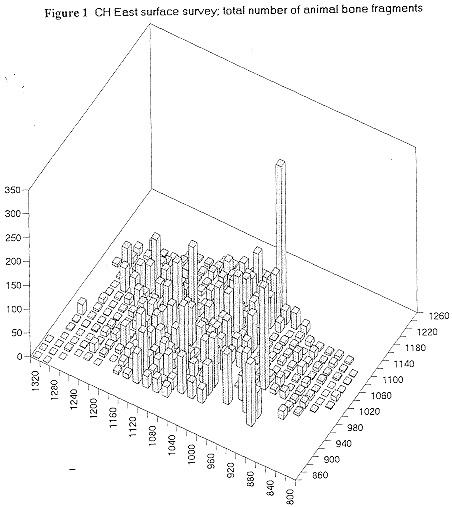
Figure 1 shows how the total of 7120 fragments are distributed across the 298 squares sampled (in both 1993 and 1994); in all figures, north is to the left. Bone counts are used instead of weights since there is a high correlation between the two (r=.79). The density of bone varies greatly across the site, and the patterns observed in 1993 report remain unchanged: high bone densities are found in three areas:
- on the southern part of the eastern eminence;
- on the north and west sides of the main mound; and
- on the northern eminence.
Low densities are seen on the southern part of the main mound, on its summit, on the northern part of the eastern eminence, on the north-west part of the mound, and generally around the outer edges of the whole mound.
Attempts to correlate bone patterns with other finds resulted in the following:
correlation (1993 material only)
bone (total counts) with obsidian blades .32
bone (total counts) with obsidian chips .20
bone (total counts) with handmade sherds .33
This suggests that there is no strong relationship between the presence of animal bone and the presence of Neolithic sherds (handmade) or Neolithic tools (obsidian blades).
An impressionistic visual 'correlation' was noted, however, between the high density of bone and the percentage of handmade sherds of total sherds (which was impossible to test due to the differences in quantification). This means that there is less bone present where there are large numbers of Classical period sherds. It should be pointed out that the 'correlation' described here is with the relative proportion of Neolithic sherds and not with their absolute counts, since Classical period sherds generally swamp the whole site.
Two suggestions have been offered to explain the bone: handmade sherds relationship:
i) that later activity either masks or destroys bone. This assumes that the bone is primarily of Neolithic origin.
ii) that surface bone derives mainly from the Classical period activity, but is deposited separately from the highest density of Classical period sherds.
In order to explore this further, I examined the bone fragmentation patterns in the area where wheelmade sherds are highest. This area is characterized as having an average of 17 fragments of <2cms per square, and an average of 5 frags >2cms per square. By contrast the rest of the mound, which was characterized as one general area, has an average of 46 frags <2cms and 7 frags >2cms per square. It appears, therefore, that the area with the highest proportions of wheelmade sherds is loosing the smaller bone fragments rather than the large, which might be taken as support for the idea that concentrated Classical period activity has obscured or destroyed bone. Although this might lend support to the argument that the majority of bone on the site is of Neolithic origin, this is clearly impossible to say.
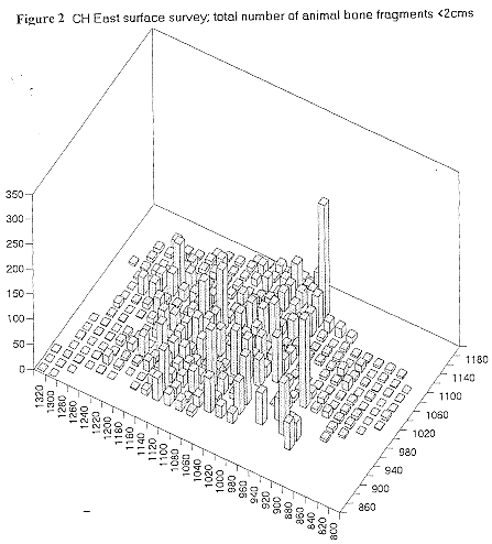
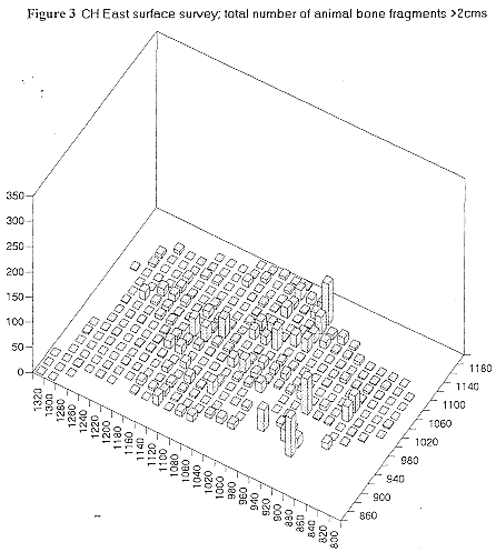
Elsewhere on the mound, the counts of smaller bone fragments (<2cms) and larger bone fragments (>2cms) appear to be roughly linked (Figures 2 and 3): on a very broad level, an increase in one class is accompanied by an increase in the other, suggesting that the pattern is underlain by density.
Explanations for the broad variations in density of animal bone across the site (Figure 1) require detailed integration with topographic, sediment and artifact information, plus a correlation with the archaeological features below. Factors which are likely to have played a part in the distribution, however, are both depositional and post-depositional: they include the actual depositional patterns of the bone itself, and the presence of other materials, the sizes and condition of deposited bone, the nature of the deflated/eroded deposits which yielded the bone material, the steepness of the mound's slopes and direction of water erosion, the vegetation cover, and the degree of later activities on the mound (e.g. surface trampling/ploughing). Without consideration of all these factors, interpretation of distribution patterns is problematic.
Identifiable bone
The following skeletal elements/zones were considered 'identifiable':
- skull: occipital condyles, petrous temporal, horn cores, max. teeth (when >half present)
- mandible: tooth rows, single teeth (when >half present), mandible bone and condyle
- all long bones
- scapula, proximal and neck only
- pelvis, acetabulum only
- carpal/tarsals: astragalus, calcaneum, naviculo-cuboid, scaphoid, semi-lunaire, capetumtrapezoid only.
- phalanges
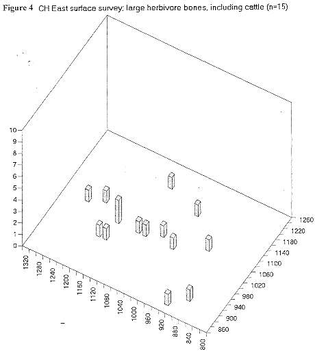
A total of 127 bones were identified, the majority belonging to sheep/goat, with the next most common category being undiagnostic medium-sized herbivores (although the range of other taxa would suggest these could probably be also classed as sheep/goat).
| cattle | lg. herbivore | sheep/goat* | med. herb | pig/boar | fox |
| 10 | 5 | 61 | 43 | 5 | 3 |
*both sheep and goat identified.
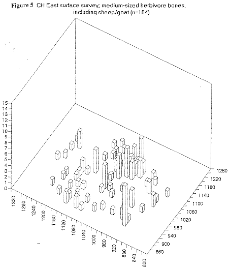
The distributions of large herbivore bones (which includes cattle) are shown in Figure 4: no pattering is evident. Medium-sized herbivore bones, including those of sheep and goat, are plotted in Figure 5. When compared to the overall densities of bone fragments (Figure 1), it appears that the number of identifiables probably relates to higher overall densities of bone (eg. squares (1100, 1000) (1120,1000) (1140, 1000) (1160, 1000)), i.e. they are dependent to some degree on sample size (cf. Grayson 1981).
With regards to skeletal part representation, only the medium-sized herbivore plus sheep/goat category is large enough for comment. Ratios for the presence of proximal:distal humerus and proximal:distal tibia (both bones which have dense distal ends and less dense proximal ends, following Lyman's 1994 measures for deer), are 3:8 and 1:4 respectively. Sample sizes are extremely small, but might indicate some density-related disappearance (or erosion leading to non-identifiability) of bone.
Sub-surface scrape
Table 1 presents the animal bone data from the 10x10m2 areas which were included in the sub-surface scraping programme from both the 1993 and 1994 seasons. The information given includes:
- the total number of fragments per square (broken down into the vertically stratified units - usually comprising the scrape layer, topsoil and the vegetation layer - reading from the bottom)
- the total weight of fragments (grams)
- the average weight per fragment (grams)
- the volume of deposit excavated (m3 dug)
- the density of fragments per square (frags/m3)
- the percentage of identifiable bone (given in both counts and weights)
Two points are noteworthy. Firstly, the density of animal bone varies considerably both across the mound and also within broad areas. The highest density by far comes from square 1040,1040 on the east side of the main mound (569 frags/m3); while the lowest density is seen in square 1010,950 on the south side of the main mound (1 frag/m3) . The 16 adjacent squares scraped on the northern eminence show a range of 6 to 94 fragments/m3, with those in the northern half of the block having higher densities, although the most north-easterly squares show low counts. This may in part reflect the effects of the slope, with higher densities deriving from the flatter squares.
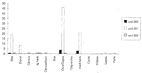
Second, it is interesting to note that the average weight per fragment consistently increases with increased depth. If the weight of a bone fragment is taken to reflect its size, then this might indicate that bone fragmentation is higher closer to the surface. Having said this, it should be pointed out that the majority of bone from the scraped squares derives from the middle 'topsoil' unit (see Figure 6, where unit 281 represents topsoil).
Test square 1020,1170
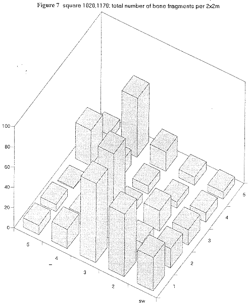
One of the reasons for studying the finds from the surface and sub-surface scrape collections was to attempt to determine the extent of disturbance of the deposits. The pottery assemblages serve as a fair indicator of how 'pure' the Neolithic deposits may be (e.g. by calculating proportions of Neolithic to Classical type sherds), and to what degree they may be representative of the Neolithic architecture exposed by scraping. By contrast, the faunal remains proved very difficult to assess in terms of their post-depositional history. One way, however, of attempting to gauge the relationship between the bones and the underlying deposit was to create expectations of attributes of the bone fragments. The material from square 1020,1170 was collected in smaller (2x2m) units than other scrape squares. It was therefore possible to relate the location of the finds more closely to the deposits and architecture exposed. Great variations were noted in this 10 x 10 m square between areas of intense burning, widespread ashy deposits or unburnt deposits, and it was decided to count burnt bone fragments from each 2x2m unit.
Figure 7 shows the numbers of bone fragments in each 2x2m area collected in square 1020,1170. The area where deposits were most intensely burnt, showing black and white coloration, is in the east of the square (1,2; 1,3; 2,3). Elsewhere, deposits were ashy and grey. Table 2 below gives the percentages of bone fragments recorded as either burnt black or burnt white; as can be seen, there are highly burnt bones in squares 1,2 and 1,3 but there are higher counts in a few other squares. In addition, there are no burnt fragments in 2,3 which has apparently highly burnt deposits.
These results suggest that, for this square at least, the bone material collected from the sub-surface scraping may not be directly, entirely, or maybe in any way related to the architectural plans which have been exposed.
Table 2. The percentages of burnt bone per 2x2m square in 1020.1170 (north facing upwards)
5 |
11 |
0 |
0 |
6 |
25 |
4 |
0 |
0 |
0 |
7 |
0 |
3 |
14 |
0 |
13 |
0 |
0 |
2 |
11 |
18 |
0 |
0 |
0 |
1 |
39 |
11 |
0 |
11 |
7 |
1 |
2 |
3 |
4 |
5 |
Identifiables
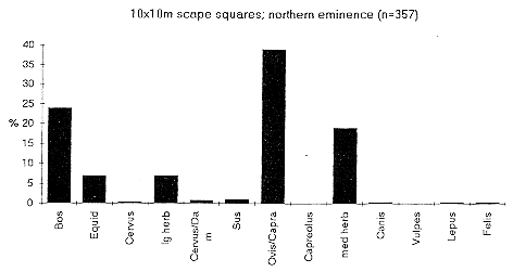
The taxa identified from the sub-surface scraped areas are sheep/goat (Ovis sp. / Capra sp.), cattle (Bos sp.), equid (Equus sp.), red deer (Cervus sp.), red / fallow deer (Cervus sp. / Dama sp.), roe deer (Capreohis sp.), pig/boar (Sus scrofa), dog/wolf/jackal (Canis sp.), fox (Vulpes sp.), hare (Lepus sp.) and cat (Felis sp.). Sheep/goat dominate in all squares, followed by cattle with equids usually being the next most common. Categories of medium-sized herbivores and large herbivores were used for fragments which could not be identified to genus.
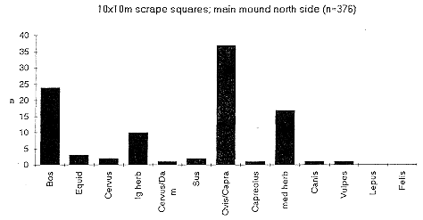
The squares within each main area of the mound showed such similar patterns that results have been amalgamated. Figure 8 shows the relative proportions of taxa for the northern eminence, Figure 9 for the north side of the main mound, and Figure 10 for the east side of the main mound. It is clear also that the general pattern is repeated between areas. It is interesting to compare these Figures with the relative proportions of identifiable pieces from the surface collection (2x2m2) (Figure 11). Here, the proportion of cattle bones is 10%, whilst they constitute approximately 25% of each of the subsurface scrape samples. There are many possible ways of explaining this difference, but one suggestion might be that the increased fragmentation of surface material has made the larger bones harder to identify. Another possibility is that the patterns reflect real differences, and that fewer cattle and large herbivores bones were present in the deposits which formed the present surface of the mound, than there were in those which are presently just below the surface.
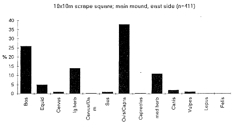
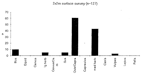
The west mound
Surface collection
A total of 1851 fragments of animal bone were recovered from the surface sampling, and their distribution and densities are shown in Figure 12. A lower density of fragments was found on the west mound surface than on the east (8.7 fragments per square as opposed to 23.9).
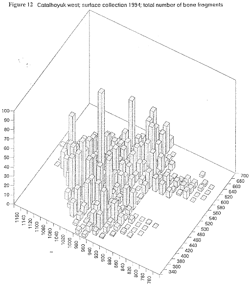
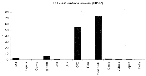
The relative proportions of identifiable taxa are shown in Figure 13. It interesting to note that the overall percentage of large herbivore fragments (including cattle) identified from the west mound is 6.8%, whilst the equivalent figure from the east mound surface collection is 11.8%. It is difficult to speculate as to whether this is a taphonomic bias or a real difference in trends between the two mounds.
Conclusion
These preliminary results of the study of the animal bone from the Çatalhöyük surface collections show that patterns are present in the data. Explanation of these patterns relies heavily on integrating the data with those from other specialist studies, something which has only been hinted at in this report. As excavations proceed, it will be a valuable exercise to compare the patterns which have been gleaned from the detailed analyses of surface data with those from the well-stratified contexts below; a lot of useful information on the depositional and erosional history of the site will be forthcoming.
Louise Martin
Institute of Archaeology, UCL
London
December 1994
References
Behrensmeyer, A.K. (1 978). 'Taphonomic and Ecologic Information from Bone Weathering', Paleobiology 4(2), 150-162.
Grayson, D.K. (1 98 1). 'The Effects of Sample Size on some Derived Measures in Vertebrate Faunal analysis', Journal of archaeological Science 8, 77-88.
Lyman, R.L. (1994). Vertebrate Taphonomy, Cambridge: Cambridge University Press.
| |
© Çatalhöyük Research Project and individual authors, 1994